


|
||

|

|
|

|
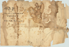
Rare early map of Auburn, New York.
A plan of the village is in the map's center, with large views of the Theological Seminary and the State Prison on the left and right corners.
Nine views of public buildings are on the right, some of which have "J.J. Hagaman, Arch." written below. Beneath the title is a profile of the Erie Canal. The entire map has a stark, black and white aspect, heightened by the view of the State Prison which has a black sky above it.
Decorative map of Auburn, first settled by Col. John L. Hardenburgh in 1793 as Hardenburgh’s Corners. Auburn was incorporated in 1815. The Erie Canal brought further prosperity to the town and by 1837 the population hand grown to over 5,000.
The Presbyterian Theological Seminary (1819) and State Prison (1816) are shown. Despite an economic downturn following the financial Panic of 1837 the village again began to flourish with the population expanding to 30,345 persons in 1900.
Engraved by M.M. Peabody, with 11 prominent buildings in vignette and a full profile of the Erie Canal.
J.L. Hagaman of Hagaman & Markham was a noted architect and master builder located in Auburn and is credited as architect on three of the perspective vignettes. A table at left includes a key to the locations of 31 landmarks and a list of the number and type of merchants and services in Auburn. A proposed railroad through the northwest quadrant of the village, labeled simply as “Railroad”, carries a steaming locomotive, tender and passenger cars in vignette.
Our thanks to Chris Muscavage of Primitive Pieces for the above description.
![[Niagara Falls] Cataracte de Niagara](https://storage.googleapis.com/raremaps/img/small/96890.jpg)