|
||

|

|
|

|
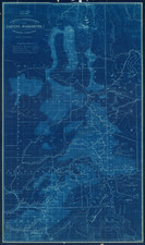
Rare separately published map of "the Puget Sound Country," published by Bellingham Bay Abstract & Title Insurance Company.
A remarkable advertising map issued to promote settlement, development and tourism. The maps shows Puget Sound and the region to the east. The map extends to Stevens Pass and the Boston Mine in the east, and south to include Olympia and Mt. Rainier, which is drawn outside the map's neatline.
A table of references identifies principal cities, county and international boundaries, numerous railways, soundings in fathoms in the harbors, U.S. military naval and lighthouse reserves.
The map includes red overprinting, illustrating the distance from Bellingham in 10 mile increments. Also in red overprinting is "Complements of the Pacific Realty Co. C.X. Larrabee President . . . Bellingham . . .."
At the top right, the map notes that the Cities of Fairhaven and Whatcom have consolidated to become Bellingham, as of October 27, 1903, with a population of 25,000.
![[Map of the United States, illustrating the routes of the Canadian Pacific Railway and the Seattle, Lake Shore and Eastern Railway]](https://storage.googleapis.com/raremaps/img/small/71080.jpg)