The item illustrated and described below is sold, but we
have another example in stock. To view the example which
is currently being offered for sale, click the
"View Details" button below.
1912 William Rand & Andrew McNally
$ 175.00


|
||

|

|
|

|
Stock# 57885
Description
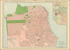
Updated to the Year of the 1906 Earthquake
Large format highly detailed map of San Francisco, showing towns, wharfs, rail lines, street car lines, roads, buildings, etc.
Large inset of San Francisco Bay. The best large format map of San Francisco to appear in a 19th century commercial atlas.
A fine example of this highly detailed map from Rand McNally's Indexed Atlas of the World, perhaps the best large format late 19th century atlas published in America.
![[ San Francisco / Bay Area ] Welcome Map of San Francisco and the Bay Area](https://storage.googleapis.com/raremaps/img/small/96705.jpg)

![[ Spanish Flu -- Masks -- Armistance Day WWI ] The Unveiling of The Kaiser's Finish By Capt. J.F. Mora At Pittsburg, Calif, Nov 17th, 1918.](https://storage.googleapis.com/raremaps/img/small/99630.jpg)