|
||

|

|
|

|
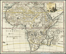
An English Rarity with Important Additions along the Cape of Good Hope -- Overton’s Striking Map of the African Continent
Extremely rare, decorative map of Africa, which includes new place names along the Cape of Good Hope, illustarting the Dutch colony established in 1652.
The map is framed tightly around the continent, with the Arabian Peninsula included. Madagascar is slightly hooked to the east, showing the influence of Blaeu’s earlier map of the continent. Additionally, Blaeu’s influence is evident in the configuration of the large central lakes in southern Africa which give rise to the major rivers of the continent.
There are two large lakes at roughly the same latitude, a convention from traditional Ptolemaic geography. Another Ptolemaic holdover is the mountain range to the south of the river, the Mountains of the Moon, or Moone as Overton spells it. A stream from the north of both Zaire-Zembre Lake and Zaflan Lake combine to form the Nile River. Another stream from Zaire-Zembre becomes the Congo River.
Slightly farther south is another, smaller lake, this one called Zet Sachaf Lake. It gives rise to the Cuama, or Zambezi, River and, farther south, the Rio de Spirito Santo, or the Limpopo. Waldseemuller included a similar lake, Sacaff Lacus, on his 1507 world map. This was copied as Sachaf Lacus or Saphat Lacus on later works. The lake seems to be borrowed from the Egyptus Novelo, a tabula nova drawn by Pietro del Massaio. Although the lake has rivers rising from it, Waldseemuller never attached these to the Nile. However, in 1525 Laurent Fries did just that and later authors followed his convention. However, Blaeu, a major source for Overton, followed closely the lake as drawn in Mercator’s 1569 world map. He did not draw any rivers flowing north, as if to put a stop to the possible connection of the lake with the continent’s largest river. Overton follows his example here.
At the southernmost tip of the continent, Overton has broken the border of the map to include new place names that resulted from the settlement of the Dutch at the Cape in 1652. These include Robbin Eyl, or Robbin Island, today famous for its prison, and Tasd berg, or Table Mountain.
The map is bordered on all sides with vignettes meant to communicate the dress, customs, and urban geography of the continent. They are based on Van den Keere’s work. At top and bottom are birds-eye views of (clockwise from upper left) Mina, Tangier, Tunes, Amara (the supposed home of Prester John), Algar, Canaria, Mozambique, Taffin and Ceuta. The view of Cefala has been removed to include more place names at the Cape of Good Hope.
Along the sides of the map are decorative costumed figures representing the dress of women from various African kingdoms. Portraits of kings of Africa are interspersed among the town views. At sea there are numerous ships and a few whales. A single compass rose adorns each ocean, the Atlantic and the Indian. In the Atlantic is a decorative cartouche with frames the title. There, Overton explicitly calls out his main sources, Visscher and Blaeu.
Mapping the continent of Africa in the early modern period
In the Medieval period, Africa formed one part of a tripartite worldview that combined the oikumene, or known world, of the Greeks with a Christian worldview. This was best symbolized by the T-O map, which are east-oriented diagrams, some with Jerusalem at their center, which show Asia, Europe, and Africa surrounded by the world ocean.
This understanding of the continents began to change rapidly in the fourteenth and fifteenth centuries as the Portuguese explored farther south along the western African coast. Finally, in 1498, Vasco da Gama rounded the Cape of the Good Hope and arrived in India. The opening of the trade routes rewrote the existing world maps. The 1506 Contarini-Roselli world map is the first surviving printed map to include the discoveries; Waldseemuller’s 1507 world map also shows them.
Early printed editions of Ptolemy—the first with maps was printed in 1477 in Bologna—would increasingly include tabula nova, or new maps, which supplemented Ptolemy’s ideas with more modern observations. The first modern map of the entire African continent was in Sebastian Munster’s edition of the Geographia published in 1540. Over the course of the sixteenth century, the African coastline was entirely refined from a Ptolemaic model with a closed Indian Ocean to a peninsular Africa surrounded by sea.
Abraham Ortelius’ map of the African continent, based on an earlier map by Giacomo Gastaldi, was the most widely-distributed map of the sixteenth century and it affected maps of the continent well into the seventeenth century. The Blaeu map of the continent, first published in 1617, was the next map to prove influential in altering how the landmass was understood. Blaeu added many place names from the Portuguese discoveries and those of the Dutch as they came to dominate the East Indies trade.
Overton chose the map of Nicolas Visscher as his model; Visscher was in turn influenced by Blaeu, Van den Keere, and Jodocus Hondius. Overton has translated the Dutch place names and titles into English. The main innovation of Overton in comparison to Blaeu’s map is the addition of new place names at the Cape of Good Hope.
Publication and states
This is the second state of Overton’s Africa map. The first was published in 1668 when Overton was publishing from the Whitehorse in “Little Brittaine neare the Hospitall.” By 1670, he had moved to the Whitehorse “neere ye Fountaine Tavern without Newgate.” The date, which had been rubbed out for the second state, is still faintly visible at the bottom of the cartouche.
Overton initially published this map to help him recover from the loss of many of his copper plates in the Great Fire of 1666. He produced this map, part of a set of continent maps, to compete with his fellow mapsellers Robert Walton and Thomas Jenner/Wencesalus Hollar. From 1670, he included the Africa map in his atlases.
One of the rarest and most decorative maps of Africa published in England in the seventeenth century, this map would make a fine addition to collections of Africa maps.
The Overton family was a prominent part of the printing, and mapmaking, industry in London in the seventeenth and eighteenth centuries. John Overton (1639/40-1713) was the son of a tailor who apprenticed to Stationer Thomas Gould. He was made free of the Stationers’ Company in 1663. Two years later, London was struck by the Great Plague of 1665-6. Peter Stent, a leading printseller, succumbed and Overton took over his shop. This burned in the Great Fire of 1666, but Overton had rebuilt by 1669, when he advertised his wares from the White Horse on Snow Hill. Overton specialized in prints, portraits, and especially maps and topographical views.
John was likely married three times and had seven children. His eldest, Thomas, emigrated to America. His second oldest, Henry, was executor of John’s will when the latter died in 1713. Henry (1675/6-1751) acquired his father’s stock in 1707 and ran the shop until his own death in 1751. He published many maps, most focusing on the British Isles. His shop and stock passed to his nephew, another Henry, son of John’s fourth son, James.
Henry the Elder’s brother, Philip (ca. 1681-1745), was also a printer and mapmaker. Philip served as his father’s apprentice and was made free of the Stationers’ in 1702. His father set him up in the trade in 1707 and by 1710 he was working from the sign of the Golden Buck in Fleet Street. Philip specialized in fine arts prints, including Hogarth’s Hudibras set (1726), but he also sold many maps. At his death in 1745 he left his shop to his widow, Mary. She ran the shop and then married James Sayer, whose brother, Robert, became Mary’s assistant. He took over the business in 1748 and became a famous purveyor of maps, charts, and views.
Back at the sign of the White Horse, Henry the Younger continued the family business, expanding their stock to include a large collection of landscape views. He often partnered with Robert Sayer. He continued in business until at least 1764, when he drops out of the historical record.

![[Untitled Map of The Atlantic Ocean, Europe, Africa, the Middle East, and Eastern Canada]](https://storage.googleapis.com/raremaps/img/small/89582.jpg)