
This item has been sold, but you can enter your email address to be notified if another example becomes available.


|
||

|

|
|

|
Stock# 57808
Description
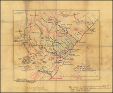
Detailed sea chart of the South African coastline, published by Aime Robiquet in 1854.
Includes extensive annotations showing several ships sailing tracks around the Cape of Good Hope in the 1860s.
Inset maps show:
- False Bay et Table Bay
- Port Natal
- Baie Algoa
- Baie Delagoa
- Ile Dyer et Pointe Danger
- Cap des Aiguelles
Condition Description
Annotated with tracks of early expeditions. Soiled at lower centerfold. Other signs of use and soiling.
![[ First Modern Map of Southern Africa ] Tabula Moderna Secunde Porcionis Aphricae](https://storage.googleapis.com/raremaps/img/small/66800.jpg)
![[South Africa]. Charte der Sudspitze Africa und der Colonie vom Vorgebirgedernugen Hoffnung haputeschilich nach Barrow's Neuesten Reisen enworfen und nach astronomischen Ortsbestimungen. . . .1804](https://storage.googleapis.com/raremaps/img/small/47947.jpg)
![(South Africa) Coutumes Moeurs & Habillemens des Peuples Qui Habitent aux Environs du Cap de Bonne Esperance avec une Description des Animaux et Reptiles qui set truvent dans ce Pais [Customs, Manners, and Attire of the Peoples Who Inhabit the Vicinity of the Cape of Good Hope, with a Description of the Animals and Reptiles Found in this Country.]](https://storage.googleapis.com/raremaps/img/small/89738.jpg)