|
||

|

|
|

|
From An Atlas Designed To Educate A Future King of England
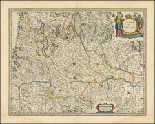
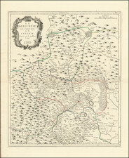
A decorative map of easternmost France and northern Italy during classical antiquity, containing ample notes regarding the region's past classical histories. A second, smaller map of Calabria and part of Sicily is also included. All cities and geographical features are shown with their Latin names.
The map includes a decorative title cartouche and the royal coat of arms.
This map was part of a special geographical text dedicated to the Duke of Glocester, who was then attending school in Oxford. Unfortunately, the Duke would die at age 11.
Edward Wells was a Church of England clergyman and advocate for education. He published prolifically, including several atlases of the ancient and contemporary world. Wells was the son of a vicar and entered Christ Church, Oxford in late 1686. He graduated BA in 1690, MA in 1693, and worked as a tutor at his college from 1691 to 1702. Then, he entered into a living at Cotesbach, Leicestershire, from where he continued to publish his many works. He attained the degrees of BD and DD in 1704, after he was already at Cotesbach.
From roughly 1698 onward, Wells wrote many sermons, books, and atlases. He focused on catechismal and pastoral works, as well as educational books. For example, some of his first works were mathematics texts for young gentlemen, which included how to use globes and determine latitude and longitude. He also translated classical and Christian texts, sometimes adding geographical annotations.
His descriptive geographies were not overly original works, but they were popular in their time. First, he produced a Treatise of Antient and Present Geography in 1701; it went on to four more editions. Next was a Historical Geography of the New Testament (1708), accompanied by a Historical Geography of the Old Testament (1711-12).
![(War of the Austrian Succession) [Manuscript Map of the Surroundings of Savona in Liguria]](https://storage.googleapis.com/raremaps/img/small/87693op.jpg)