


|
||

|

|
|

|
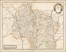
A Map of Ile de France with Military scenes within the map
Rare map of the area around Paris, published in Paris by Jean Le Clerc.
The map tracks the Seine River from (Monterrau Sur Jonne) Montereau, Fontainebleau and Melun through Paris to Mante and Vernon.
Chartres appears in the lower left corner, with Brie and Limoges also shown. A contemporary manuscript note "comte Robert" appears next to Brie.
The map includes several sections with h military scenes.
- Near the towns of Annet (Anet) and Yvery (Evereux), a force of mounted and foot soldiers appears near the caption R. de France et de Navarre.
- South of Corbeil-Essonnes, there are cannon, foot soldiers and mounted soldiers. Corbeil was besieged by the Duke of Burgundy in 1418. The Protestants of France attacked it in 1562 amidst the religious war called the First Civil War. In 1590 General Alessandro Farnese, who had come to the assistance of the Catholics in France, fought at Corbeil.
- The largest scene appears east of Paris, near Laigny, Bois d. Vincene, Meaux and Ferte (La Ferté-sous-Jouarre).
Jean Le Clerc was an engraver, bookseller and publisher in Paris and Tours.
Le Clerc was baptized on August 16, 1560 in Paris, with the engraver François Desprez (1530–1587) and the painter Jérôme Bollery (1532–1592) as his godfathers. He came from a family of printers and publishers - Jean's younger brother David Le Clerc (1561–1613) and Jean's own son Jean Le Clerc V were both book printers and publishers.
He had proved himself by 1587, at which date he was living and working on Rue Chartière in Paris. For religous reasons, as a Huguenot he fled Paris in 1588 and spent a year elsewhere in France. From 1590 to 1594 he took refuge in Tours, where he worked with the publisher and cartographer Maurice Bouguereau (15??–1596), who created Le Theatre Francoys, the first atlas of France. Le Clerc later worked at several different addresses in Paris - on Rue Saint-Jean-de-Latran until 1610 and then on Rue Saint-Jacques until 1621/24.
Jean Le Clerc's publications included portraits, maps, contemporary news events and other engravings by Jacques Granthomme (1560–1613), Pierre Firens (1580–1636) and Léonard Gaultier (1561–1635). He collaborated with the Dutch printmaker Thomas de Leu (1560–1612) to produce a collection of 179 biblical scenes, allegories, calendar pages and other works, probably published in 1606. They both produced engravings for it themselves as well as using works by Justus Sadeler (1580–1620), Isaac Briot (1585–1670) and Nicolas Briot (1579–1646).
On December 20, 1619 Le Clerc was granted a six-year royal concession to "engrave maps of the provinces of France and portraits of patriarchs and princes of the Hebrew people, with a chronological history". In 1620 he published his Le Théâtre géographique du Royaume de France, including newer plates as well as reworked plates from Bouguereau's work. The new plates were produced by artists such as Jean Fayen (1530–1616), Jodocus Hondius (1563–1612), Salomon Rogiers (1592–1640) and Hugues Picart (1587–1664). It went through several editions and Jean Le Clerc V continued to reissue it after his father's death.
![[Stop The Fake News!] Halte au Menteurs! Les Colo Bacilles Sement La Haine!](https://storage.googleapis.com/raremaps/img/small/59951.jpg)
![[ France ] Galliae Regni Potentiss: Nova Descriptio Joanne Ioliveto Auctore . . .](https://storage.googleapis.com/raremaps/img/small/97834.jpg)
![[ France ] Galliae seu Franciae Tabula, qua omnes Provinciae, Viae angiariae, et aliae res notatu dignae distincte et accurate ostenduntur . . .](https://storage.googleapis.com/raremaps/img/small/98436.jpg)