|
||

|

|
|

|
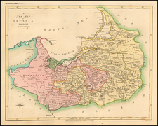
One of the Earliest Detailed Sea Charts of the Baltic Coastline
Finely engraved sea chart of the Baltic coastline. Shows the area from Estonia in the north to Liepāja in Latvia, along with some of the islands in the south of Finland, which appeared in Blaeu's Her Licht der Zeevaert or Le Flambeau de la Navigation, first published in 1608.
The map would later be copied by Jansson in 1620, when the Blaeu copyrights expired.
The chart is oriented with east at the top and includes compass roses and a sailing ship.
The charts for this atlas are titled in both Dutch and French and are extremely rare. This is the only example of the chart we have seen on the market in more than 20 years.
Willem Janszoon Blaeu (1571-1638) was a prominent Dutch geographer and publisher. Born the son of a herring merchant, Blaeu chose not fish but mathematics and astronomy for his focus. He studied with the famous Danish astronomer Tycho Brahe, with whom he honed his instrument and globe making skills. Blaeu set up shop in Amsterdam, where he sold instruments and globes, published maps, and edited the works of intellectuals like Descartes and Hugo Grotius. In 1635, he released his atlas, Theatrum Orbis Terrarum, sive, Atlas novus.
Willem died in 1638. He had two sons, Cornelis (1610-1648) and Joan (1596-1673). Joan trained as a lawyer, but joined his father’s business rather than practice. After his father’s death, the brothers took over their father’s shop and Joan took on his work as hydrographer to the Dutch East India Company. Later in life, Joan would modify and greatly expand his father’s Atlas novus, eventually releasing his masterpiece, the Atlas maior, between 1662 and 1672.
![Gibraltar to Berlin. [World War II Broadside Map.]](https://storage.googleapis.com/raremaps/img/small/83480.jpg)
![[ Poland ] Regno di Polonia](https://storage.googleapis.com/raremaps/img/small/69618.jpg)