|
||

|

|
|

|
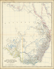
An Unusual Variant of An Important Early Sydney Plan
Rare and highly detailed map of Sydney, oriented with west at the top, printed in Sepia and dated 1837.
This map illustrates the settlement of Sydney as of 1837; detailing public buildings, outlining the boundaries of the parishes of St Phillip, St James, St Lawrence and St Andrew and highlighting in green government owned land. Includes landmarks such as Fort Macquarie at Bennelong Point, Fort Phillip above The Rocks (Observatory Hill), Barrack Square and the military barracks (Wynyard), the wharves of Darling Harbour and the extensive Hyde Park and Government Domain. At the far left of the map, past the Brickfields and the cattle market is the burial ground for the town.
This is apparently an updated version of the 1831 cadastral plan of Sydney by William Wilson. The additions are typically shown in dashed lines (see for instance the additional wharves to between Marke Wharf and Steel's Wharf, which are not present on the earlier map.
The map differentiates in the key between Public Buildings (shaded rectangles) and Other Houses (unshaded).
A note indicates "The site proposed for Gov't House and improvements in that vicinity area shewn by dotted lines, also proposed prolongation of George Street."
At the bottom left, the map notes that it was "Drawn at the Survr. Genls. Office. A second credit in the bottom right is illegible.
The N.S.W. General Post Office Directory
In 1832, the year after the New South. Wales Calendar and General Post Office Director, had been first published, the Surveyor-General's Department, headed by T .L . Mitchell, with S.A. Perry as his Deputy, was the largest in the state, with twenty surveyors employed, and six more in the Road Branch; there were also six draftsmen and four clerks.
An official Town Plan of Sydney was engraved in 1831, titled 'Map of the Town of Sydney, 1831', drawn and engraved for the N.S.W. General Post Office Directory by permission of the Surveyor General, by William Wilson. It accompanied the first Directory compiled by James Raymond, Postmaster of N.S.W., with assistance from various government departments. It was the first publication to include a directory of householders as well as marking clearly the public buildings.
As well as containing a List of Towns and Stations, it recorded useful information about the public institutions in the colony, and the names of those who staffed them, and it included an 'Index to the Several Roads' radiating out from Sydney. It gives a picture of the colony as it was developing by that time, and also includes the base map which forms the basis for subsequent maps issued during the decade of the thirties. There were two versions of this map: one was included as a folding map to the Directory, and the other was sold separately.
Source of Map
It appears that this state of the map, printed in red, appeared in Maclehose's picture of Sydney, and strangers' guide in New South Wales, for 1839 : embellished with forty four engravings of the public buildings and picturesque land and water views in and near Sydney. The National Library of Australia's FC F2795 copy is printed primarily on white pages but also has blue, green and pink pages bound in; bears bookplates ex-libris John A. Ferguson and National Library Ferguson collection. The volume is bound in brown cloth with an embossed design of leaves on both covers. The map, titled "Map of the Town of Sydney, 1837" is printed in red.
The remanants of the Picture of Sydney title can be seen at the bottom of this example.
Rarity
The map with the various journals is scarce on the market, but this example, printed in Sepia, is apparently very rare.