|
||

|

|
|

|
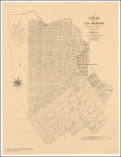
Rare Early Map of San Francisco, Printed on Linen
Zakreski's map of San Francisco is one of the most important of the great early maps of San Francisco. Published in 1852, it is one of the first maps of San Francisco published in San Francisco and the earliest map printed on linen west of the Mississippi River.
Unlike some other important early maps of San Francisco, this map was wholly a product of the city itself. The map was based on the work of County Surveyor William Eddy, who was responsible for virtually all of the late-1840s and early-1850s mapping of San Francisco. It was lithographed by Alexander Zakreski, and sold by Cooke & Le Count, 'Stationer's' [sic] at Montgomery Street.
Gold Rush-era maps of San Francisco that were produced in San Francisco are quite rare, and this is one of the first. Eddy's Official Map of the city of San Francisco was published by B.F. Butler's Lith. in the city a year earlier.
The map shows the projected and accomplished infill of the city into San Francisco Bay, about which more later, and it includes insets of the new city hall and B. Davidson's Banking House.
Large wharves are shown running into the harbor: "Broad-Way Wh."; "Pacific Wh."; "Central Wh."; "Market Wh." The map includes soundings just off the wharves. Two theaters, one American and one French, are called out in a separate key. Places of worship are likewise listed.
This map would be adapted and expanded by Zakreski and Britton & Rey in maps of San Francisco published in the following years.
Documenting Explosive Gold Rush Growth
The present map captures San Francisco at a pivotal moment in its history when Gold Rush-fueled immigration was swelling its population and putting considerable strain on the city's built infrastructure. The town had grown from less than 1,000 residents in 1849 to over 25,000 within a year.
The massive influx of people and commerce caused a building boom and a search for viable new land. San Franciscans were quite creative in their efforts to expand the city, and much building was done on the city's tidal flats. This included the extension of wharves, plank streets, and the intentional beaching of ships to be turned into commercial buildings.
Rarity
The map is exceedingly rare. We know of only one example (printed on paper) which appeared at auction in the past 50+ years, purchased by Warren Heckrotte at PBA in 2006 and resold in the Heckrotte collection by PBA in 2015, now David Rumsey 12216.
We are not aware of another example printed on fabric offered for sale.
An essential work for San Francisco Collectors.

![[Berkeley] This Is The Map of Berkeley Town Its Streets Go Winding Up & Down An Oak-Covered Campus It Wears For A Crown With People & Places of Renown](https://storage.googleapis.com/raremaps/img/small/97201.jpg)