This item has been sold, but you can enter your email address to be notified if another example becomes available.


|
||

|

|
|

|
Stock# 57322
Description
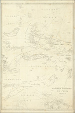
Rare military map showing part of the Island of Luzon, issued at the height of the Philippine-American War, compiled by William L. Sibert of the 8th Army Engineering Corp.
The map covers central Luzon, from Manila Bay to Lingayen Gulf. The map shows the lines of operations for Major General H.W. Lawton, Major General A. Mac ARthur and Brigadier General L Wheaton.
During the early stages of the Philippine-American War, this area was largely controlled by Philippine forces and was the most active theater.
Condition Description
Minor toning at folds.