


|
||

|

|
|

|
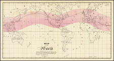
Comparing the Observations of Newton, Bradley and Maupetius
Rare map centered on Europe, without the western part of North America or the Pacific.
The map includes tables showing variations in longitude and latitude, as calculated by Newton, Bradley and Maupertuis.
Philippe Buache (1700-1773) was one of the most famous French geographers of the eighteenth century. Buache was married to the daughter of the eminent Guillaume Delisle and worked with his father-in-law, carrying on the business after Guillaume died. Buache gained the title geographe du roi in 1729 and was elected to the Academie des Sciences in the same year. Buache was a pioneering theoretical geographer, especially as regards contour lines and watersheds. He is best known for his works such as Considérations géographiques et physiques sur les découvertes nouvelles dans la grande mer (Paris, 1754).
Jean-Claude Dezauche (fl. 1780-1838) was a French map publisher. Initially, his work focused on engraving music, but he later turned primarily to cartography. His is best known for editing and reissuing the maps of Guilluame De L’Isle and Philippe Buache, two of the most skilled mapmakers of the eighteenth century. He acquired the plates of these two men’s work in 1780 from Buache’s heir, Jean-Nicolas Buache. Dezauche's business received a further boon when he received a privilege to sell the charts of the Dépôt de la Marine. His business was carried on by his son, Jean-Andre Dezauche.
![[Japanese World Map] Kaisei Chikyu Bankoku sankai yochi zenzu setsu (Revised map of all countries on the globe/ Map of the world and its mountains and oceans)](https://storage.googleapis.com/raremaps/img/small/43034.jpg)
![[ The First Zoological Map / 3 Volume Pioneering Work on Biogeography ] Tabula Mundi Geographico Zoologica sistens Quadrupedes hucusque notos sedibus suis adscriptos editit E. A. W. Zimmerman . . . [with] Geographische Geschichte des Menschen, und der allgemein verbreiterten vierfüßigen Thiere, nebst einer hieher gehörigen Zoologischen Weltcharte, von E.A.W. Zimmermann, Professor am Kollegio Carolino zu Braunschweig.](https://storage.googleapis.com/raremaps/img/small/104951.jpg)