


|
||

|

|
|

|
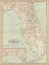
Manuscript Map of the 1838 Seat of the Second Seminole War in the Okefenokee Region -- General Charles Rinaldo Floyd
Manuscript map of the Okefenokee swamp region in Southern Georgia and the northernmost part of Florida during the second Seminole War (1835-1842), joined with with an associated envelope and Free Frank of John Quincy Adams.
The map's primary feature is the location of a number of named and unnamed forts surrounding the Okefenokee Swamp and the location of the route of Captain Benjamin Lloyd Beall and his detachment of soldiers tracking Indians through the region in September 1838. Because Beall's name is used to describe the trail and the map identifies forts that were constructed several months later, we have concluded that the most likely source of the map was a soldier who participated in General Charles Rinaldo Floyd's campaign through the region in November 1838.
The map is quite possibly the only surviving cartographic artifact of the US Military engagement in the Okefenokee Swamp region in 1838, in the midst of the Second Seminole War and more specifically the movements of the forces led by General Charles Rinaldo Floyd in November 1838.
The map shows the area bounded in the southwest by the Suwanee River, in the southeast by the St. Mary's River and in the north. While the provenance of the map at the time of acquistion was that it had been drawn by Thomas B. Adams (nephew of John Quincy Adams) while stationed in the Cherokee Nation in 1830, the map was almost certainly drawn in the second half of 1838, the year after Adams death in December 1837 at Fort Dade, Florida. The original owner and likely source of the map is almost certainly Major Greenleaf Dearborn, a commanding officer who served in the region during the Second Seminole War. As the collection in which this group was acquired was stated to have come by direct descent from Major Dearborn's daughter, Annette Maria Dearborn Boyd (see provenance section below), it must be assumed that the items were combined by later heirs.
Dating The Map
While the provenance of the map at the time it was acquired (see below) claimed a provenance relating to Thomas B. Adams and John Quincy Adams and a date of 1830, the map almost certainly dates to 1838, in the midst of the Second Seminole War. The geographical details covered, and most notably the location of the unnamed fort at Hogan's Ferry (Fort Moniac) and the detailed depiction of "Captain Beall's Trail" were instructive of the earliest possible dating A note in the Army and Navy Chronicle dated September 18, 1838 from Ft. Heilemann in East Florida noted:
The skirts of the Okefanoke Swamp have been lately examined by Capt. B[enjamin] L[loyd] Beall, 2d Dragoons, and Capt. Morris 2d Infantry, who were unable to perceive any signs of the enemy.
Captain Beall's expedition was chronicled in the following correpsondence published in the Army and Navy Chronicle, Volume VII (1838) at page 120.
Correspondence of the Army and Navy Chronicle. “Camp Moniac, Hogan’s Ferry, E[ast] F[lorida] August 5, 1838 [Captain T. Morris?]
I am alone with my company, in a perfect wilderness of pine woods and cypress swamps, and get no papers or news of any kind. . . .
The Okefonokee swamp is the haunt of a body of hostile Indians, (God only knows how many) who are in the habit of occasionally murdering a family of those hardy sons of the forest who have settled near the borders of the swamp. They also steal their cattle, corn, &c. Last month General Taylor ordered two companies of dragoons and two of infantry to be stationed on the borders of the swamp for the protection of the inhabitants, and to scout for Indians.
Captain B[enjamin] L[loyd] BEALL, with his company of the 2d dragoons, and Lieutenant G. W. PATTEN, commanding company G 2d infantry, have erected a fort on the Suwanee near the S. W. corner of the swamp in Georgia, and called it Fort GILMER (in honor of the Governor of Georgia) where they are now stationed.
I was ordered to establish myself and company at this place, (near the head of the St. Mary’s and the S. E. corner of the Okefonokee swamp, in Florida) rather east from Fort Gilmer and 28 miles from it, and the same distance from Trader’s Hill, the head of navigation of the St. Mary’s, whence I derive my supplies. I arrived here on the 24th ult., having erected a block house, store house, etc., and I called the post Fort Moniac, after the late Major David Moniac, a Creek and an officer of the regiment of Creek volunteers, who was killed in an action with the Seminoles at the Wahoo swamp [November 21] 1836. He was a friend and classmate of mine at West Point, and as a small tribute of respect to his memory I call my fort in the wilderness by his name.
Based upon the inclusion of Beall's expedition, Fort Moniac (still unnamed) and the group of Forts constructed in November 1838 (Fort Tattnall and Fort Walker), along with the location of the "Old Indian Field," the map was almost certainly drawn during the march of General Charles Rinaldo Floyd in November 1838, as reported in the Army and Navy Chronicle:
SEMINOLE WAR: From the Savannah Georgian.
FROM THE OKEFENOKE - We have been favored by a gentleman of this city, with the following interesting letter from Gen. Floyd, giving an account of that gallant officer having explored this hitherto inaccessible and unknown region. It will be seen that Gen. Floyd passed through it from S. W. to N. E., and that he has discovered the island which has hitherto served as a strong hold and lurking place to the blood-thirsty Indian, after his excursions of blood and murder.
TRADER HILL, Nov. 17th, 1838
On the 5th inst. I left here with only four companies of my regiment, (one mounted, and the rest on foot,) for Fort Gilmer, on the Suwanee river, distant fifty-six miles, and arrived there on the 6th. On the 7th and 8th, examined the country, and proposed to enter the Okefenokee, which is twenty-one miles from Fort Gilmer. On the 9th, having added one company of U. S. Dragoons, (dismounted) and two companies of volunteers to my small force, and stationed small detachments on the border of the Suwanee to prevent the escape of the enemy, I marched from Fort Gilmer for the Okefenokee, on the eastern bank of the Suwanee, and reached the edge of the swamp on the 10th, and on the same day built a picket fort for a depot for provisions, and called it Fort Tattnall.
On the 11th sent back to Fort Gilmer my baggage train, cavalry horses, tent and camp equipage; and leaving a lieutenant and fifteen men at Fort Tattnall, entered the Okefenokee, and after marching about four miles, (half the distance through muddy and dismal swamps) arrived at an island called by the Indians Chepucky. On this island is an old field and the remains of an Indian town, called Chepuckytolofa, which means Chepucky’s town. On the western edge of the island is a small lake, which I suppose to be connected with the Suwanee near its source. Built a fort on the island and called it “Fort Walker,” in compliment to a gallant officer. I entered the swamp at Fort Tattnall on what is called the old Mickasuky trail, which was followed by Capt. Beall last August, about three and a half miles into the swamp beyond Fort Walker. Being unprepared to go further, he turned back, having gone further into the swamp than any other white man up to that time. The trail followed by Capt. Beall was supposed to lead to an island about the centre of the swamp, celebrated in Indian tradition, and which he supposed to be (if it existed) the head quarters of the enemy. Nov. 12th, sent one hundred men with a guard to bring in our provisions from Fort Tattnall to Fort Walker, on their shoulders, and slung on poles, the trail being impassable to horses.
This arduous duty was handsomely performed. 13th, marched from the island with about 250 men, leaving a captain and twenty-nine men at Fort Walker. Our course was, N. E., with very little variation for 83 hours, through one of the most horrible swamps on the face of the earth. Below us was mud and water (sometimes nearly waist deep) and roots and logs, and above were briars, vines and bushes, forming altogether obstacles that no language can accurately describe. Each man carried five days provisions, nothing else save his rams and ammunition. In the evening, (having marched by our calculation twelve to fourteen miles from Fort Walker), we emerged from the swamp and entered the island which we sought, never before beheld by the eyes of white man. It was, as I expected, the head quarters of the enemy.
We found their camp and a town with comfortable houses, but the enemy had gone by their signs about two months ago. Encamped in a beautiful hammock of live oak and laurel trees. 14th, explored the island and burnt the Indian town. The island (which my officers have named Floyd’s island, and by which name it will hereafter be known) is about 20 miles long, very high, and shaped like a crescent, one end pointing to the west and the other to the north, the concave side fronting N. W. On this site of the island is an extensive prairie, level as a lake, and covered with short grass, and adorned with beautiful islands, from which (over the prairie) the woods on the border of the swamp may be seen about 20 miles to the S. W. and N. W. The Okefenokee, instead of being a barren waste, contains some of the best lands in Georgia. Floyd's island appears to divide the source of the Little St. Mary’s river from the Suwanee. Deer, bear, and turkeys are very numerous on the island, and thousands of wild geese and ducks are on the prairies. In the deep swamps there is no sign of either deer or other large animals, and but few birds are seen.
15th. Sent one company back to Fort Walker, and marched early with the rest from the island, determined to force a passage, if possible, to the main land, in a N. E. direction, For eleven and a half hours we bogged through mud and water, sometimes entangled in vines, briars, and thickets, and sometimes in open ponds and prairies; at times we were bewildered, our provisions were nearly exhausted, and we were in a wilderness unknown to us; but I was determined not to turn back, so dreadful was the Swamp over which we had passed. Several times I sent my men up trees to look out for land, for we felt as if we were on the ocean; and at last, near Sunset, we were rejoiced at seeing the green tops of pine trees over the gloomy cypress, about five miles distant. It was long after dark before we emerged from the swamp, and when we reached dry land, we were the most miserable creatures that ever walked on two legs; wet, hungry, and nearly dead from fatigue. On the march several men were bogged so deep that it required two men to pull them out, and many on landing were without pantaloons and shoes, these articles being torn off by briars, roots, and quagmires. I marched at the head of the troops, carrying my haversack of provisions as a common soldier, and suffered greatly; but it is a satisfaction to me to have performed what all other men have deemed impossible: to cross the Okefenokee with an army.
Our course was through the middle of the swamp, from S. W. to N. E.; we came out about twelve miles north of Traders’ Hill. The last day’s march is computed to be eighteen or twenty miles. Our discoveries in the swamp will be of great utility; they will enable us hereafter to exclude the Indians from the Okefenokee, their hiding place for half a century; and will open to the citizens of Georgia new sources of wealth in the rich lands of the swamp.
To-morrow l shall march to Cox's Hammock, on the west side of the swamp, and commence operations at that point, intending to scour the western border of the swamp to Fort Gilmer. The departure of the Indians from Floyd’s island justifies a report in circulation about a month ago, that they had gone to Western Florida. If any Indians are in the swamp they do not exceed forty or fifty, and are on the western border of the Okefenokee. My intention is to search every place. I shall establish a strong fort on Floyd's island, and make a road to it from Fort Walker, sufficiently good for pack horses. By holding the interior, the enemy will be forced to the border, where they can be easily found. I have placed all the regulars in this part of Georgia under my command, and find them very efficient.
Map Maker
The only clue as to who might have made the map is on the verso, where the name C.B. Mims appears. While it is unknown if the map was actually drawn by Mims, this is almost certainly the same C.B. Mims referenced in the History of Clinch County, Georgia. Mims was commissioned March 18, 1839 for a 4 year term as Justice of the Peace for Clinch County. At the time, Clinch County included Echols County, Georgia. The majority of the land shown on the map is in these counties.
Integration of Map Information
The cartographic details on this map do not appear on any printed map prior to 1839. In 1839, the information from Beall and Floyd appears to have been recorded for the first time in the Map of the Seat of War in Florida, Compiled by Bvt. Brig. Genl. Z[achary] Taylor in 1839. One of the images incorporated with this description is a section of the 1839 Seat of War map. The full map can be seen here: https://www.raremaps.com/gallery/detail/42589
The information was not present the prior year in the 1838. Map Of The Seat Of War In Florida. Compiled By Order Of The Hon. Joel R. Poinsett.
While the map is a relatively rough sketch map, we find no evidence of any contemporary printed or manuscript maps which show this area in detail prior to the 1839 Seat of War map.
Place Names Shown
The following topographical names are given to various rivers, etc.
- Okefenokee Swamp: The vast majority of the map is attributed to the Okefenoke and surrounding rivers.
- Suwanee River:
- St Mary's River
- Alligator Creek
- Jones Creek (Clinch County, Georgia)
- Cyprus Creek
- Bone's Creek
- Breakfast Branch (Suwanee River)
- Indian Swamp
- Cyprus Swamp
- Suwan-uche Swamp:
The following man-made landmarks appear:
- Indian Old Field: referenced above by General Floyd -- the site of Camp Walker on what is now Billy (Bowlegs) Island.
- Hammack
- Camp Pocket: Pocket Run or Slough was described as running 17 miles from the west side of the Okenfenokee swamp. In The WPA Guide to Georgia: The Peach State, in describing an area near Homerville, Georgia, near Jones Creek the guide notes: "the road [State Highway 89] continues across a peninsula called the Pocket, where General Charles Floyd Built Fort Tatnall during an expedition against the Indians in 1838."
- Unnamed Fort (Fort Tatnall?): See above
- Unnamed Fort (Fort Walker?): See above. "Fort Walker (1) (1838), a blockhouse northeast of Fort Tatnall on "Chepucky Island" (location ?)." (GEORGIA CIVIL WAR HERITAGE TRAIL . HISTORIC CHATTAHOOCHEE COMMISSION website describing Georgia Forts). Another (Boys Life, September 1947), places Fort Walker on Billy's Island, Georgia, named for Billy Bowlegs, the Seminole Chief.
- Captain Beal Trail
- Ft. Gilmer (Echols County)
- Trail from Ft. Gilmer to Hogan's Ferry
- Hogan's Ferry: A small log defense on the west-side of the North Prong St. Mary's River, about one mile from the Georgia border. (an 1840 map places this fort inside Georgia)
- Unnamed Fort near Hogan's Ferry (Fort Moniac, Florida)
- Old Ford
- Crew's Ford
Acquisition -- Provenance
The map was acquired from Case Auctions in Nashville, Tennessee. The description for the lot read as follows:
Hand drawn Okefenokee Map, and 2 John Quincy Adams signed free franked envelopes, 3 items total.
1st item: Ink on paper hand drawn map depicting the area comprising the Cherokee Nation lands in Georgia, dated circa October/November 1830. The map depicts forts, trails, and other areas of interest including Hogan's Ferry with a trail leading from Fort Gilman (established and abandoned within a year), Camp Pocket, the Indian Old Field Pino, several interconnect trails marked as Captain Bealle's Trail, and other locations in an around the Okefenokee Swamp.
[verso] Map Okefenokee" with several rudimentary sketches of buildings, rivers, and other topographical features and the signature "C.B. Mims", en verso. Single directional arrow pointing North, center of map. 7 7/8" H x 9 7/8" W.
2nd item: John Quincy Adams signed free franked envelope after his term as 6th President of the United States (1825-1829) addressed to his nephew Thomas Boylston Adams, Jr., (1809-1837), High Tower, Cherokee Nation, Georgia, dated circa October/November, 1830. It refers to the Okefenokee Map with notation reading "Quincy Map Oct 22" with additional notation reading "Rec'd Nov 5th Friday 1830. Ansd " 14th Sunday ".
Address and notation about map in writing probably by a secretary or local postmaster, other notations possibly by Thomas B. Adams, Jr. 3 5/8" H x 5 1/4" W. . . . .(with Biography of TB Adams)
3rd item: Fragment of John Quincy Adams signed free franked envelope after his term as 6th President of the United States (1825-1829). "FREE" stamped in red lettering below signature. Pencil notation reading "J Q Adams 1833" above.
verso Fragment of letter referring to a Cadet and a Squad, en verso (does not appear to be written in Adams' hand). 2 3/4" H x 2 1/8" W.
Provenance: The Estate of Charles Boyd Coleman, Jr., Chattanooga, TN. Descended in his family from Charles Harrod Boyd, grandson of Charles Harrod (1787-1870). Charles Harrod was the brother of Ann (Anna) Frances Harrod Adams (wife of Thomas Boylston Adams, 1772-1832, the son of President John Adams).
Note: Charles H. Boyd's wife, Annette Maria Dearborn Boyd, was the daughter of Greenleaf Dearborn (1786-1846) and great granddaughter of Maj. General Henry Dearborn (1751-1829) on her mother's side. She and Charles Harrod Boyd had four children, including Julia Wingate Boyd, who married Lewis M. Coleman, Jr., Chattanooga, TN, a direct descendant of John Marshall (1755-1835). John Marshall was the Fourth Chief Justice of the United States and also served as Secretary of State under John Adams (1800-1801)
Charles Rinaldo Floyd
Charles Rinaldo Floyd (1797 - 1845) was an American planter, politician and military leader most famous for his leading the Trail of Tears out of Georgia and for his Okefenokee Campaign during the Second Seminole War. He wrote one of the first published accounts of the Okefenokee Swamp.
In May 1838, under orders from Governor Gilmer, Charles Rinaldo Floyd commanded troops effecting removal of Cherokee Indians from northern Georgia. Indian families were rounded up and placed in internment camps before their forced march out West – known as teh The Trail of Tears.
Floyd was next appointed brigadier general of the Georgia militia in October 1838 and ordered to meet five companies and chase a party of Seminoles out of the Okefenokee Swamp. The Indians refugees had been forced north during the Second Seminole Wars, and their presence caused anxiety and conflict in the south Georgia. Floyd wrote letters detailing his Okefenokee campaign to regional newspapers. The Savannah Georgian printed his first letter, and multiple newspapers reprinted it. He wrote that it was “a satisfaction to me to have performed what all other men have deemed impossible; to cross the Okefenokee with an army.”
Benjamin Lloyd Beall
Benjamin Lloyd Beall (1801–1863) was a United States Army officer, was born in 1801 in Washington, D.C. Beall was admitted to the United States Military Academy at West Point on January 1, 1814, but left on October 15, 1818, without graduating. He was elected captain of the Washington City Volunteers for service in the Seminole War on June 1, 1836, and was commissioned as a captain of the Second Dragoons in the regular United States Army on June 8, 1836. He was brevetted major on March 15, 1837, "for gallantry and successful service" against the Florida Indians.
In April 1846 he was stationed in San Antonio, where he was ordered to escort German immigrants to Fredericksburg and the Pedernales. He was promoted to major of the First Dragoons on February 16, 1847, and on March 16, 1848, received a second brevet, to lieutenant colonel, for his part in the battle of Santa Cruz de Rosales. After the Mexican War he was stationed in New Mexico until February 1848, when he took the First Dragoons into El Paso and established Fort Bliss. He was promoted to lieutenant colonel on March 3, 1855. At the beginning of the Civil War, on May 3, 1861, he was promoted to colonel; he was then assigned to command the First Cavalry, formerly the First Dragoons, on August 3, 1861. Beal retired from active duty on February 15, 1862.
Thomas B. Adams
Thomas B. Adams served as a Cadet at the Military Academy, July 1, 1824, to July 1, 1828, when he was graduated and promoted in the Army to Bvt. Second Lieut. of Artillery, July 1, 1828. He served: in garrison at Ft. Monroe, Virginia. in 1828‑29 and Ft. Moultrie, South Carolina in1829‑30.
He was stationed in the Cherokee Nation, 1830 and later in garrison at Charleston Harbor, 1830‑31. In 1831‑32; he was in the Cherokee Nation, 1832; on Ordnance Duty, December 13, 1832.
Adams subsequently saw action in the Second Seminole War,being engaged in the Skirmishes at Camp Izard, February 27, 28, 29, and March 5, 1836, and Action of Oloklikaha, March 31, 1836. He died of Malaria at Fort Dade, Florida on December 14, 1837. The post was declared unhealthy and abandoned for the summer in 1838 and the Seminole Indians burned it and the bridge down. The site was occupied sporadically until finally abandoned at the end of the war in 1842.
Rarity
The map would seem to be unique. We find no similar manuscript maps in any institutional collections.
![[ Florida Indians ] Ceremonia a Saturioua in expeditionem adversus hostes profecturo, observatae. XI](https://storage.googleapis.com/raremaps/img/small/86474.jpg)

![[ Florida Indians - Preparations for a Feast ] Conviviorum apparatus](https://storage.googleapis.com/raremaps/img/small/98462.jpg)