|
||

|

|
|

|
Rare Early Edition -- Previously Owned by the Duke of York
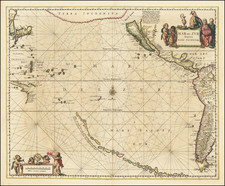
The Duke of York's Copy of the rare first state of Sheet 1 of Braddock Mead's seminal map of the Pacific Ocean, published in London by Thomas Jefferys.
In 1899, Henry Stevens noted that the first state of the map was apparently intended to be sold in separate sheets, noting that it is "very rarely complete, as the 6 charts has a complete border and title so that they were evidently sold separately as required."
The map is one of the few maps published in the 18th Century to focus on the Coast of California, with California spelled "Kalifornia" in his edition.
The map includes interesting coastal details and numerous sailing ships, illustrating the transatlantic voyage routes of Behring, Tchrikow, De L'Isle de la Croyere, Frondate, Cavendish, Gaetan, Wallis, Spilbergen, Anson, Mendanna and others.
Emphasis is placed upon Drake's discoveries and a red line is drawn signifying where the English claims based upon Drake's first discoveries would begin.
A very curious feature of the map is the note "Port Sr. Francisco Drakw 1578. not St. Francisco," with the Farollone Islands just off the coast. This map pre-dates the discovery of the actual San Francisco Bay by 16 years, yet curiously gives the correct name and a decent representation of where the Bay would be found, although no evidence that we know of supports an earlier discovery or naming of the bay.
The map Includes a number of factual and annecdotal annotations, including notes about Juan De Fuca, Admiral De Font and others. Drake's discovery and claims are noted, as is the bay discovered by Martin d'Aguilar. The River of the West is shown as a water course connecting the to the Mississippi River, just south of Lake Winnepeg. The discovery of the land by the Chinese Geographer Fou-Sang is also noted.
Thomas Jefferys became geographer to the Prince of Wales in 1746 and geographer to the King in 1760. He published a remarkable number of maps and charts, many of the North American continent.
The genius behind Jefferys in his shop was a brilliant man who at this time went by the alias of John Green. He made a great six-sheet map of North and South America (1753), concerning which he said, 'The English charts of America being for the general very inaccurate, I came to a resolution to publish some new ones for the use of British navigators.'
In addition to his extensive cartographic abilities, Green's personal history also stands out from amongst the biographies of other 18th-century British map makers. John Green was born Braddock Mead in Ireland before 1688, married in Dublin in 1715 and around 1717 moved to London. He was imprisoned in 1728 for trying to defraud an Irish heiress. He also worked with Chambers on his Universal Dictionary.
After he got out of jail, he took the name of Green, and subsequently worked for Cave, Astley, and Jefferys. Mead 'had a number of marked characteristics as a cartographer ... One was his ability to collect, to analyze the value of, and to use a wide variety of sources; these he acknowledged scrupulously on the maps he designed and even more fully in accompanying remarks. Another outstanding characteristic was his intelligent compilation and careful evaluation of reports on latitudes and longitudes used in the construction of his maps, which he also entered in tables on the face of the maps ...
Mead's contributions to cartography stand out ... At a time when the quality and the ethics of map production were at a low ebb in England, he vigorously urged and practiced the highest standards; in the making of maps and navigational charts he was in advance of his time. For this he deserves due credit." (Cumming).'
Complete sets of the six maps are rare. In 1991, the Dupont set sold for $12,000 hammer; in 2007, the Frank Streeter set sold for $60,000. A separately-issued pamphlet which was intended to accompany the map is seldom found together with the map. Lada-Mocarski quotes an 1899 Henry Stevens catalogue concerning the map: "We have never before met with the Remarks and Chart together. The latter is very rarely complete, as the 6 charts has a complete border and title so that they were evidently sold separately as required."
While later states of the map appeared in Jeffery's Atlases, commencing in about 1775, this first state is exceptionally rare.
Provenance
The present example includes the bookplate of the Duke of York. The map was apparently acquired by the Duke of York and bound into a large composite atlas, as noted by the number below the Duke of York's bookplate found on the upper left verso of the map (illustrated), bearing the motto of the Chivalric English Order of the Garter, "Honi Soit Qui Mal Y Pense" and the initials D.Y., along with "Vol. 68, No. 11."
The Duke of York as a Prolific Map Collector
Frederick Augustus, Duke of York and Albany, (1763-1827), was the second son of King George III, and much like his father, a prolific collector of books and maps. A grand library was a necessity for a gentleman of his standing in Georgian Britain, regardless of his occupation, but as a lifelong military man (eventually Commander-in-Chief of the Forces), it was especially important for the Duke of York.
The Duke collected maps, prints, and books throughout his life. In the 1790s, he commissioned the printseller Holland to gather rare 18th-century satirical prints into a series of albums for him. That collection grew to encompass four albums and several hundred prints. His book collection was larger by several orders of magnitude; when it was finally sold after his death in 1827, it took 22 days (starting on May 7, 1827) for Sotheby's to sell the 5548 lots of books from his library. As the Duke of York was not directly in line for the Crown, his collection did not become part of the Royal Collection.
At the end of the 200-page Sotheby's book sale catalog was an advertisement for the sale of the Duke's over-800-lot map collection:
MAGNIFICENT MAPS AND CHARTS.
The most extensive and invaluable Selection of MAPS and CHARTS, the Property of HIS ROYAL HIGHNESS THE DUKE OF YORK, DECEASED.
Including a Grand Classical Arrangement of "Chartae Geographicae"; or a Collection of Maps and Charts in reference to Ancient and Modern Geography, contained in Eighty-Six [actually Eighty-Eight] Atlas Book-Boxes, 2 feet high by 16 inches wide, uniformly bound and lettered with the Contents.
The Duke of York's Chartae Geographicae Map Collection
The map collection was of vital professional interest to the Duke, as well as an obvious focus of his collecting passion. And the crowning jewel of the map collection was the 88-volume boxed set of maps, each bearing the Duke of York's bookplate (with his coat of arms and "DY") as well as the volume number and map number.
In Harley and Walters' article on early English map collecting, they identified the Duke's boxed-map collection as being the most important from the period:
This item, lot No. 238, was in itself a veritable map library of world-wide proportion. It was cited in the catalogue as 'Chartae Geographicae antiquae et recentiores-Collection-in reference to antient and modern geography, consisting of 5,500 maps, engraved by the early modern geographers, contained in 88 folio Double Book Cases, and properly lettered'. It was sold for £400 to Cochran.
Select maps from the Duke of York's collection have appeared on the market in the last few decades, though we have not been able to trace the actual volumes beyond their sale to Cochran (almost certainly the London bookseller John Cochran) in 1827.
Thomas Jefferys (ca. 1719-1771) was a prolific map publisher, engraver, and cartographer based in London. His father was a cutler, but Jefferys was apprenticed to Emanuel Bowen, a prominent mapmaker and engraver. He was made free of the Merchant Taylors’ Company in 1744, although two earlier maps bearing his name have been identified.
Jefferys had several collaborators and partners throughout his career. His first atlas, The Small English Atlas, was published with Thomas Kitchin in 1748-9. Later, he worked with Robert Sayer on A General Topography of North America (1768); Sayer also published posthumous collections with Jefferys' contributions including The American Atlas, The North-American Pilot, and The West-India Atlas.
Jefferys was the Geographer to Frederick Prince of Wales and, from 1760, to King George III. Thanks especially to opportunities offered by the Seven Years' War, he is best known today for his maps of North America, and for his central place in the map trade—he not only sold maps commercially, but also imported the latest materials and had ties to several government bodies for whom he produced materials.
Upon his death in 1771, his workshop passed to his partner, William Faden, and his son, Thomas Jr. However, Jefferys had gone bankrupt in 1766 and some of his plates were bought by Robert Sayer (see above). Sayer, who had partnered in the past with Philip Overton (d. 1751), specialized in (re)publishing maps. In 1770, he partnered with John Bennett and many Jefferys maps were republished by the duo.

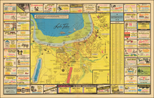
![[ Ventura ] Automobile Road Map of Ventura County California . . .](https://storage.googleapis.com/raremaps/img/small/99431.jpg)