|
||

|

|
|

|
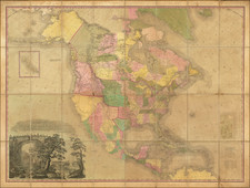
Nice example of first state of Esnaut & Rapilly's rare separately issued map of the British Colonies in North America, published in Paris.
Fascinating large format map of the Theater of War in North America, in the midst of the American Revolution. The map extends from the eastern part of North America from the Hudson Bay to the Gulf of Mexico, extending westward as far as modern day Galveston. Esnauts & Rapilly first issued the map in 1777, with Phelippeaux and Brion de la Tour re-issuing the map with a different title and minor revisions in 1778 and 1779, following the signing of the Treaty of Alliance between France and the fledgling United States, which brought the American Revolutionary effort to the attention of the French public.
The map draws from John Mitchell's landmark map of 1755. It presents the colonies in superb detail, identifying cities and towns, forts, roads, Indian villages and tribal territory. Curiously this map attempts to offer both a French and an English mapping of the region. French Louisiana extends eastwards as far as the Appalachian Mountains and westward well into territories claimed by Spain, but shows the original British Colonial grant for Virginia and Carolina grant, extending westward to the edge of the map. The fact that Louisiana west of the Mississippi had been ceded to Spain following the French and Indian War does not seem to be acknowledged. What is acknowledged is the cession of Upper Louisiana, north of 40 degrees latitude and east of the Mississippi, to the British, under the 1763 Treaty of Paris. This important treaty effectively gave the British control of the lucrative fur trade in the upper Mississippi Valley and eventually gave rise to the North West Company and the era of the Mountain Men in the early years of the 19th century.
This map also depicts the Great Lakes in a curious fashion. In Lake Superior, the islands first shown on Bellin's 1744 map were later shown by Mitchell and are present. Following the Revolutionary War, the 1783 Treaty of Paris used the islands to form the official border between the United States and Canada, including a reference to these islands ("by Lake Superior north of the islands and royal Phelipeaux to Long Lake"). It was not until the official U.S. - Canada border surveys of 1820 that the existence of these islands was finally brought into question.
Texas is called the "Pays de Cenis," referring to the Cenis tribe which, from the 16th through the 18th centuries, was one of the largest and most powerful tribes in the American southwest. Known for their hospitality towards European travelers, the Cenis are remembered for amicably hosting La Salle, Onate, Coronado, and other early explorers. In fact, in the Cenis language the word for welcome is "Techas, Techas", meaning "friend". Eventually "Techas" become known as "Tejas" and, in time, "Texas". With the French and subsequent American settlement of Louisiana, as well as the exodus of the Natchez and Chocktaw from Alabama, the Cenis were confined to a smaller and smaller territory surrounding the Trinity (Trinidad) River - as their villages are shown here. Eventually the remaining Cenis and a large group of emigrating tribes met in a great battle on the Bank of the Trinity in which the Cenis nation was utterly destroyed.
Rarity
This is the first time we have offered the map for sale.
Provenance: Colonial Williamsburg Collection, sold by Jeffery Evans Auctions, June 2018