|
||

|

|
|

|
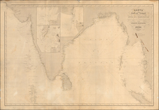
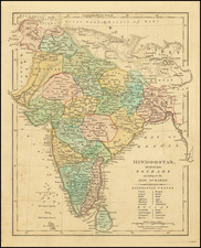
Rare sea chart of the coast of India from Point Jigat to Cape Ramas including the coasts of Guzarat and Concan with the Gulf of Cambay, showing depth soundings and sandbanks.
Fine English sea chart of the region from Goa in the south to Gujarat in the north, covering the Northwestern coastline of India. Centered on Mumbai, the chart is one of the rarest English Sea charts to cover the region in the 18th Century. The chart was first published by William Herbert, in his A New Directory of the East Indies (London, 1758).
During the Seven Years’ War (1756-63) British fortunes in Asia significantly changed. Britain supplanted France as the dominant maritime power in the Indian Ocean, leaving her free to expand her influence eastwards.
William Herbert
Following the death of John Thornton, the East India Company had no organized system compiling and publishing sea charts. As the number of ships bound for East Asia, British mariners were left to utilizing outdated charts or relying upon foreign published charts from French and Dutch sources, which were also increasingly out of date. By the 1750s, the toll of ships lost due to navigational errors was driving up insurance premiums, let alone the cost in blood and treasure
In 1754, the British East India Company (EIC) supported William Herbert's venture to gather the best available hydrographic intelligence as a means of significantly upgrading available charts. This represented a great leap forward in the preservation and dissemination of maritime cartography by the EIC.
William Herbert (1718–95) was an English bookseller who had spent the years 1738 to 1745 in India working for the EIC. While there, he gained an impressive knowledge of the geography and hydrography of the Indian Ocean and South and Southeast Asia. Following his return to London, he established a print and map-selling business at ‘the Globe under the Piazzas, London Bridge’. While other commercial chartmakers thrived in London, the EIC and British Navy had an immediate need for a more progressive, reliable charts of the African and Asian Coastlines.
Herbert carefully selected the best sources from unpublished manuscript charts in British archives and the most progressive foreign printed sources, such charts from the first edition of Jean-Baptiste d’Après de Mannevillette’s Le Neptune Oriental (1745), in order to create his new sea atlas. Herbert issued the first edition of his atlas, A New Directory of the East Indies (London, 1758), which included 30 largely original charts.
The second edition of his New Directory appeared in 1759, expanded to 48 maps. Unfortunately, in 1759, Herbert's shop burned. Ironically, this provided Herert more time. Working with the archives of the EIC and its new hydrographer, Alexander Dalrymple, Herbert significantly improved his work. In 1764, Herbert entered into partnership with William Nichelson, a British mariner and fine chart maker, who had returned from six years’ service in India and Africa with his own magnificent manuscript charts. A third edition of Herbert's New Directory appeared in 1767, followed in 1776 by a fourth edition, which was expanded to 136 charts. After Herbert retired, his work was continued by his successors, Henry Gregory I & Henry Gregory II and the latter’s partners, who issued follow up editions of the New Directory in 1780 and 1787.
The New Directory was highly regarded during its time and played an important role in both commercial and military navigation during a critical period of British expansion in Asia. It was used almost exclusively by professional mariners and pilots, and was never issued in mass production. As the atlases were thus heavily used at sea, very few examples of any of the editions have survived.
Rarity
The chart is very rare. This is the first example we have seen on the market.
The English mapmaker William Herbert (1718-95) traveled to India in about 1748 as a purser's clerk. Herbert's cartographic publishing started to take form in the late 1740s, when he set up a map and print shop on London Bridge. In 1758, with the encouragement of the East India Company, he introduced a new pilot guide, A New Directory for the East Indies. Herbert gathered superior sources than those used in Mount & Page's The Third Book, consulting such works as Mannevillette's Neptune Oriental, as well as the navigator William Nicholson and the cartographer Samuel Dunn. He often worked with colleagues, including Jefferys, Sayers, Dury, and Andrews, and is recorded as a seller of the famous Anti-Gallican map. In 1776 he retired, having apparently made a fortune. His business was carried on by Henry Gregory Sr.