|
||

|

|
|

|
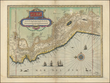
The Only Surviving Example of The Gutierrez Map of the New World in Private Hands
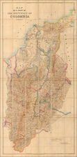
Rare separately published map extending from Florida and Texas in the north to just south of the Amazon River, published in Antwerp by Hieronymous Cock, from the cartographic work of Spain's Diego Gutierrez.
The Gutierrez-Cock map is a truly unique production, the only large format map of America detail published from direct Spanish sources in the 16th Century. the first of its kind to be devoted solely to the Americas. Entitled America Sive Qvartae Orbis Partis, Nova et Exactissima Descriptio, Gutierrez's wall map highlights the sovereignty of King Philip II of Spain, who is depicted gliding over the waves among sumptuously engraved sea monsters.
Originally published in 1562, the complete wall map in 6 sheets survives in 2 examples The present example was re-issued in Paris in 1630 as a single sheet map, this being the only known example in private hands (the BnF holds the only known institutional example (2)).
Florida
in Florida, the map includes a number of early place names, including:
- Costa de Caracoles (Coastline of Sea Shells -- first used in the 1530s -- Alonso de Chaves)
- Rio de canoas
- La florida
- Bay de S. Iuseph
- Ba. de Iua ponce
- R. de Lapas
- B. de la guaro di Martiles
- Costa de fuego
Texas & Gulf Coast
Along the Gulf Coast, the map extends to Cabo de Crux. This would appear to be the "Cabo de X" which appears on the 1548 Gastaldi map of the Southwest, immediately west of the Bay of Espiritu Santo. On May 8, 1541, Spanish explorer Hernando de Soto became the first recorded European to reach the Mississippi River, which he called Río del Espíritu Santo ("River of the Holy Spirit"). As such, the present map would seem to show virtually the entire Gulf Coast, west of the mouth of the Mississippi River.
Cabo de Cruz may also related to the expedition of Panfilo de Narvaez. In 1527, Pánfilo de Narváez obtained persmission for the first known exploration of Tampa Bay. In 1527, he received permission from Emperor Charles V to conquer and colonize the lands between the Cape of Florida and the Río de Las Palmas in Mexico. Launching his expedition from Cuba in 1528, he landed on the Pinellas peninsula, marched overland to Old Tampa Bay and gave it the name Bahía de la Cruz (Bay of the Cross, later changed to Bahía de Espíritu Santo or Bay of the Holy Spirit.
Other place names typically seen in Texas on maps from the 16th Century include the Rio de Loro, Rio de Pescatores, and Rio Escondido.Costa de Arboleadas and Cabo Bravo.
California
The map shows the east coast of Lower California and names the Mare Vermeio, the so called Red Sea which was the early name for the Gulf of California/Sea of Cortez.
Of greatest importance, the appearance of C. California is the earliest appearance of the name California on a printed map.
Central America
The name "Malpelo" appears below "Isla de buenaventnra" southwest of Panama and "ysola di Perla"
South America
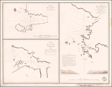
On the west coast of South America, at the bottom of the sheet, the name "Po. de lobos" appears on the present example and the British Library example, but not on the Library of Congress example.
Gutierrez's Six-Sheet Map of the New World
This remarkable map of the Americas was originally created in 1562 by Spanish cartographer Diego Gutiérrez and Flemish artist Hieronymus Cock. The map encompasses the eastern coast of North America, the entire Central and South America and parts of the western coasts of Europe and Africa. The map was the earliest large scale wall map of the New World and the first to use the name "California".
The 1562 map consists of six engraved sheets. Curiously, the map acks the Tordesillas meridian, demarcating the Spanish and Portuguese possessions in the New World. The 1562 map survives in 2 known examples, one in the Library of Congress and the other in the British Library. The Library of Congress' copy was formerly in the collection of the Duke of Gotha until its sale at a 1932 auction in Munich. It was then acquired by an American book dealer who in turn sold it to Lessing J. Rosenwald. In 1949 Rosenwald gave the map to the Library of Congress.
The map is reflective of the life of Gutierrez, its maker, in that there are no discoveries shown on the map which post-date his death in 1554. Amerigo Vespucci is credited as the discoverer of America in 1497.
The interior note on the map reads:
Peru regio Caroli V. mandato et auspitijs Ao. 1530 perlustrata est inventaque et olim hac Tenus repertarum auri ditissima; adeo ut in quoda oppido ibi inventorut domum solido auro tec tam 1630
Survival of the Map
As noted above, the 6 sheet map was originally engraved in Antwerp by Hieronymus Cock. Following Cock's death, it is know that some of his copperplates were later acquired by the French engraver Paul van der Houve. Van Der Houve, for example, issued an example of the Cock's 1553 four sheet map of Spain, Nova Descriptio Hispaniae. Later, some of van der Houve's plates came into the possession of Michael van Lochom (1601-1647), who for example re-issued the 4 sheet map of Spain with his imprint (4 surviving examples, British Library, Bibliotheque National de France and a private collection.
We note that the color used on this map matches well with the color used in the first part of the 17th Century by French mapmakers and by Van Lochom. The 1630 date
Rarity
The map is extremely rare, with the present example being the only known example with the 1630 date. Burden notes:
The original six-sheet Gutierrez map survives in 2 known examples (Library of Congress and British Library). The British Library example is in a later state, with at least two identified additional place names appearing in this sheet alone. Off the south coast of Central America appears the name ‘Malpelo’ below ‘Isla de buenaventnra’ southwest of Panama and ‘ysola di Perla’. This small island is recorded on Pierre Desceliers’ portolan map of 1550. The second addition is on the west coast of South America at the bottom of the sheet, the name ‘Po. de lobos’.
This single sheet survives in 3 known examples, 2 at the Bibliotheque National, Paris, and this one first recorded in 1967 in the ‘Map Collector's Circle’ no.34, plate 23. Only this one is dated 1630 providing a reasonable date of publication, and a third state. We have been unable to determine yet whether the two French examples include the addition toponyms. Otherwise this sheet does not differ from the British Library example.
This example was acquired in June 2018.
Hieronymus Cock (1518-1570) was a skilled Flemish engraver, painter, and publisher of prints in the sixteenth century. He hailed from an artistic family, as his father and brother were both painters as well. He trained as a painter in Antwerp and then spent time in Rome (1546-7).
Cock and his wife, Volcxken Diercx, established their publishing house in 1548 at Aux quatre vents, or at the house of the four winds. Cock’s publishing house became renowned in northern Europe as he and his wife, and successor, transformed printmaking from an individual activity to one based on a division of labor. This allowed him to publish more than 1,100 prints in just over two decades (1548-1570). He is known to have personally etched 62 plates.
Cock’s cartographic output included country maps, landscape prints, and town plans, especially of cities under siege. He also worked with mapmakers; for example, he collaborated with Diego Gutiérrez on a 1562 map of the America. He famously released prints by important engravers who produced works after the Italian masters of the Renaissance, popularizing that movement in the north of Europe.
Diego Gutiérrez was a Spanish cosmographer and cartographer of the Casa de la Contratación. He was given this post by royal appointment on October 22, 1554, after the death of his father Dylanger in January 1554, and worked on the Padrón Real.
In 1562 Gutiérrez published a remarkable map entitled Americae Sive Quartae Orbis Partis Nova Et Exactissima Descriptio in Antwerp (then part of the Spanish Netherlands) in collaboration with the printer Hieronymus Cock. The reason it was published in Antwerp was because the Spanish engravers were not skilled enough to print such a complicated document.
Gutiérrez's map features not only the Amazon River system and Lake Titicaca as well as other geographical features, but also fanciful depictions of parrots, monkeys, mermaids, huge sea creatures, Brazilian cannibals, Patagonian giants, and an erupting volcano in central Mexico.
It was the first map to print the toponym "California". It also recorded the first appearance of a word for "Appalachia," as the term "Apalchen."