|
||

|

|
|

|
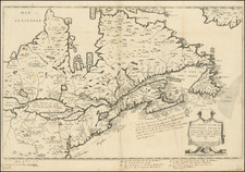
With Contemporary Manuscript Additions Showing The Action At Saratoga and around Germantown
Rare 1777 state of Esnaut & Rapilly's scarce, separately published, and attractive map of the Northeast, produced to inform the French public of the primary theatre of the early years of the American Revolution.
The map illustrates the area from Quebec to Cape May, New Jersey, and from the Kennebec River to Lake Ontario. Boundaries, counties, towns and cities, forts, roads and Indian nations are all depicted in great detail.
Of significance, the map shows in contemporary manuscript troop locations (in 4 red bars) the location of Burgoyne's surrender to the American army at Saratoga, which would later be added to the 1778 edition of the map. This victory more than any other single event induced the French to ally with the American cause in 1778 and thus is generally considered the turning point of the war. Numerous forts, minor as well as major ones, are shown and named throughout the map, including Fort Washington in northern Manhattan, those along the Delaware River, many in northern Massachusetts, and the several in the Lake Champlain/ Lake George region.
According to Nebenzahl and Sellers Van Ee this map should show the location of British troops at Frank-Fort and German Town in Pennsylvania and at Saratoga in New York. However, this first state of the map only includes the troop positions in red manuscript.
Numerous forts, minor are shown and named throughout the map, including Fort Washington in northern Manhattan, those along the Delaware River, many in northern Massachusetts, and the several in the Lake Champlain - Lake George region.
This is the first state of the map; with other states of 1778 and 1787 known.
An important French map of the northern American colonies shown at the beginning of the American Revolution. Also of interest are a number of major and minor cities including New York, Philadelphia, Albany, New Haven, Newport, and Boston, which are shown as walled cities.
A fine dark impression.
![[Colonial New Hampshire Map on Sheepskin] A Plan of a Tract of Land called Monadnock Number six, 1768, Measured according to an agreement with Thomas Packer, Esq. as Follows...](https://storage.googleapis.com/raremaps/img/small/17048.jpg)
![[Carolinas, Virginia, the Chesapeake, Pennsylvania, New York]](https://storage.googleapis.com/raremaps/img/small/71479.jpg)