|
||

|

|
|

|
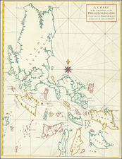
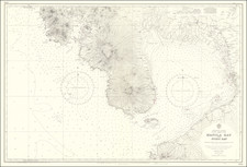
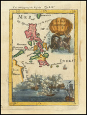
A Legendary French Rarity -- The Survey of Manilla Bay Verified by The French Frigate Meduse
Extremely rare sea chart of the Bay of Manilla, originally created in 1789 and revised to the 7th Year of the French Republic (1799).
The chart includes a profile view of the approach to Manilla Bay, centered on Mount Silanguin.
The original survey was conducted in 1789 by the Frigate Meduse. In the same time period, the Meduse was also involved in trade with Macao and private efforts to support Nguyễn Phúc Ánh, the future Emperor of Vietnam and the founder of the Nguyễn Dynasty.
The title translates:
Plan of Manila Bay and its surroundings, verified by the frigate La Meduse in 1789 and corrected, particularly regarding the positions of the (sand) bank of St. Nicolas and of Caponne Point.
We have found precious little about this survey and chart. Qurino identifies the maker as "Unknown."
Rarity
OCLC locates the copy in the Harvard Library (acquired prior to 1831) and the British Library. The Library of Congress bibliographical records suggest that the LC has held a copy since prior to 1903.
We note no auction or dealers records for the chart.
The Dépôt de la Marine, known more formally as the Dépôt des cartes et plans de la Marine, was the central charting institution of France. The centralization of hydrography in France began in earnest when Jean-Baptiste Colbert became First Minister of France in 1661. Under his watch, the first Royal School of Hydrography began operating, as did the first survey of France’s coasts (1670-1689). In 1680, Colbert consolidated various collections of charts and memoirs into a single assemblage, forming the core of sources for what would become the Dépôt.
The Dépôt itself began as the central deposit of charts for the French Navy. In 1720, the Navy consolidated its collection with those government materials covering the colonies, creating a single large repository of navigation. By 1737, the Dépôt was creating its own original charts and, from 1750, they participated in scientific expeditions to determine the accurate calculation of longitude.
In 1773, the Dépôt received a monopoly over the composition, production, and distribution of navigational materials, solidifying their place as the main producer of geographic knowledge in France. Dépôt-approved charts were distributed to official warehouses in port cities and sold by authorized merchants. The charts were of the highest quality, as many of France’s premier mapmakers worked at the Dépôt in the eighteenth century, including Philippe Bauche, Jacques-Nicolas Bellin, Rigobert Bonne, Jean Nicolas Buache, and Charles-François Beautemps-Beaupré.
The Dépôt continued to operate until 1886, when it became the Naval Hydrographic Service. In 1971, it changed names again, this time to the Naval and Oceanographic Service (SHOM). Although its name has changed, its purpose is largely the same, to provide high quality cartographic and scientific information to the France’s Navy and merchant marine.