This item has been sold, but you can enter your email address to be notified if another example becomes available.


|
||

|

|
|

|
Stock# 57081
Description
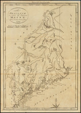
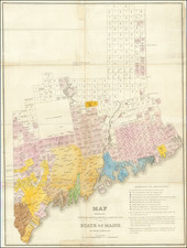
Scarce early map of Maine, based upon the surveys of Osgood Carleton.
This early nineteenth century map is based on Osgood Carleton's wall map of Maine.
The map was published by Jedidiah Morse, one of the founders of American cartography. It provides early information on the region, which at the time was a part of Massachusetts, and is divided into five counties. A line of mountains mark the boundary between Maine and Canada.
One of the earliest obtainable maps of Maine.