|
||

|

|
|

|
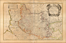
Detailed map of the Artois region in Northern France. Includes a separate sheet of town plans and an alphabetical index of towns and villages within Artois. Published in Paris by Alexis-Hubert Jaillot, circa 1700.
The map outlines the major roads and pathways around the Artois region. Many towns, villages, and communes are highlighted in red including St. Omer, Boulogne-sur-Mer, Arras, Abbeville, Doullens, Cambrai, Douai, etc. Abbeys and chateaus are indicated throughout the map along with lakes, mountain ranges, forests, and waterways. A decorative title cartouche is illustrated at the top right of the map and a scale of distance is included at the top left of the map.
The second sheet includes town plans of Arras, Hesdin, St. Omer, Bapaume, Les Aires, and Saint Venant. The third sheet is an alphabetical index of the towns and villages in Artois.
Alexis-Hubert Jaillot (ca. 1632-1712) was one of the most important French cartographers of the seventeenth century. Jaillot traveled to Paris with his brother, Simon, in 1657, hoping to take advantage of Louis XIV's call to the artists and scientists of France to settle and work in Paris. Originally a sculptor, he married the daughter of Nicholas Berey, Jeanne Berey, in 1664, and went into partnership with Nicholas Sanson's sons. Beginning in 1669, he re-engraved and often enlarged many of Sanson's maps, filling in the gap left by the destruction of the Blaeu's printing establishment in 1672.
![Cenomanorum Galliae regionis typus. Auctore Mattheo Ogerio. Le Mans [on sheet with:] Britanniae, et Normandiae Typus. 1594.](https://storage.googleapis.com/raremaps/img/small/100856.jpg)