


|
||

|

|
|

|
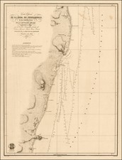
The First Printed Map of the Amazon from First-Hand Experience and the First Map Printed in South America
Rare and highly-influential map of the Amazon River basin, based upon the work of the noted Jesuit missionary Samuel Fritz. The map is one of the foundational maps of South American cartography and perhaps the finest map made in South America of the colonial period.
Fritz's map is the first printed map of the Amazon River made by someone who had explored it and served as the model for many other maps of the Amazon throughout the eighteenth century. Moreover, it was the first map printed in Ecuador and almost certainly the first map published in all of South America.
Over the course of forty years as a Jesuit priest in the Amazon basin, Fritz used only basic instruments to laboriously survey and compile this extraordinary map of the area, which was printed for the first time in Quito in 1707. The map’s rarity is due to the very limited run of the Quito printing. The map was intended solely for the officials in the Jesuit Province of Quito and the Real Audiencia of Quito, as well as state officials in Spain and religious officials in Rome, where the Jesuits were based. There is no record that it was ever offered for sale beyond this very limited circle.
The map encompasses all the vast Amazon River, one of the first maps to do so. To the east is Para, under Portuguese control. As the Amazon is traced west to its origin, it splits into tributaries such as the Rio Napo. To the west are the great cities of western South America, under Spanish control, with Quito to the north and Cuzco and Lima to the south. Cities are labeled and marked with fort symbols of varying size.
The equator neatly cuts the map in half vertically. There is more information to the west, where the Spanish controlled what is today Peru and Ecuador. As Fritz was a Jesuit missionary under the care of the Spanish Crown, this balance points to the underlying political discourses at play, as Camila Loureiro Dias points out. Fritz was making this map to show all that he achieved as a missionary and all that still needed to be done to convert and control the peoples of the western Amazon basin.
The map contains several elaborate decorative elements that carry much information. First, the title cartouche in the top center of the map is a fluttering banner. It explains that the great Amazon River is the subject of this work, “geographically delineated” by the Jesuit missionary Fritz, a “continuous missionary” on this river—Fritz’s work in the area remained ongoing. The map’s engraver is also named in the title, P. J. de N., the abbreviated name of Father Juan de Narváez, another Jesuit missionary. Importantly, Narváez's work was done in Quito in 1707, one of the first printed products to come from the Spanish colony and unquestionably the first printed map.
In the top left corner is a detailed coat of arms, representing the King of Spain to whom the map was dedicated, Philip V. Guarding the coat of arms are four figures. To the left is an angelic figure wrapped in a robe and crowned with a laurel wreath. The figure carries a cross and shield emblazoned with the Jesuit symbol, “IHS”, which are the first three letters of Jesus’ name when written with the Greek alphabet. Rays of light radiate from the shield, just as Jesuit missionaries radiate around the world in the early modern world. The global mission of the Jesuits is reinforced by the figure to the upper right of the coat of arms, which is another angelic figure trumpeting the words, “In omnem terram,” or “out into all the earth.”
The rays of the Jesuit shield are setting another figure below off balance; this figure holds a sun and moon, symbols of paganism. Finally, at the lower right is a figure intended to represent an American Indian. He wears a feather headdress and has a bow and arrow slung over his back. This figure is holding up the coat of arms, perhaps suggesting Fritz’s opinion that indigenous Americans helped to support the Spanish Empire.
In the upper right corner is another cartouche, this one surrounded by the rich tropical fruits of South America: bananas, pineapple, melons, and other treats. Exotic birds are also wound into the border. Inside, text explains that the map is dedicated to his most Catholic Majesty Philip V, who ruled Spain from 1700 to January 1724, and again from September 1724 to his death in 1746.
In the lower left corner is a scale topped with survey instruments, a nod to the Jesuit scientific training and a visual cue of the authority of this map and its maker. Just to the right of the scale is a group of indigenous Americans. Those to the left, a man, woman, and child, are shown as if un-contacted by missionaries. The man aims an arrow at a bird in the brush, while the woman and child both clutch birds that have presumably already been shot. Next to them is a fourth Indian, a man in a smock and feather headdress with a cross around his neck. He is a convert to Christianity, a status that allowed him to access the knowledge contained in the large text box in the lower right corner, to which he is gesturing.
The text box is split into two sections. The first describes the navigation and geography of the Amazon basin, which Fritz had traversed. He also includes information on the area’s ethnography and natural resources. The second part of the text, separated by the heading “Mission of the Company of Jesus,” explains just that for the Amazon region. Fritz explains that the Jesuits control 39 villages in the province of Quito with 16 missionaries; 23 of these were under the care of Fritz himself. However, these results were not without a cost—the travel between villages was dangerous and exhausting, and several missionaries had lost their lives due to the climate or at the hands of indigenous peoples.
On the map itself, geographic place names are joined by ethnographic labels. Interestingly, and in line with the message of the other decorative elements, there is a Jesuit IHS symbol slightly left of center of the map. The symbol has rays radiating from it just as in the coat of arms. These rays touch the areas of Jesuit activity in the upper Amazon basin, including especially those areas where Fritz himself worked. Overall, and as Loureiro Dias has pointed out, the 1707 map seems to argue for more support for the Jesuit missionaries of the Spanish empire, particularly as they are located so close to the disputed border region with the Portuguese Empire farther east.
Early Mapping of the Amazon River Basin
Spanish colonial cartography flourished from the time of Columbus, although few of the many maps which were made have survived today. Some of these maps were made by explorers, but most were made by three groups: cosmographers, engineers, and the Jesuits.
Cosmographers were employees of the Spanish Crown who worked at the central colonial institutions, the Casa de la Contratación and the Consejo de Indias. Using information sent from the colonies, these intellectuals compiled small-scale maps of Spanish imperial holdings and wrote treatises on colonial history and geography, a limited number of which were published.
A second group of mappers were military engineers. After sustaining attacks from pirates and privateers, and particularly after the marauding circumnavigation of Francis Drake in 1577-1580, the Spanish Crown rushed to fortify its colonial holdings. Trained engineers were sent to the edges of empire to construct forts and defenses, resulting in many plans and maps.
The final group of mappers, the Jesuits, are the most important for the Amazon basin. The Jesuit order was founded by Ignatius of Loyola, a Basque nobleman, and gained papal approval in 1540. By the late seventeenth century, they were known for being a learned order underwritten by their rigorous curriculum, the ratio studiorum, which included cosmography and cartography. It is likely Fritz gained his cartographic skill while studying for the priesthood.
Many of the Jesuits who came to Spanish America, including Fritz, were from the Hapsburg holdings in Central Europe like Austria, Bavaria, Bohemia, and Croatia. Once in their postings, these priests were the first to map various parts of the interior of South America. David Buisseret writes, “It is no exaggeration to say that many areas of the Americas were more closely mapped by the Jesuits than they would again be until the late nineteenth century” (1148). This is certainly true of Fritz’s map, which was the most influential map of the Amazon for five decades after its initial publication. It is important to mention that many of the Jesuit maps would have been impossible without the indispensable contributions of their indigenous collaborators and informants.
From the sixteenth century, the Amazon had been shown as a vast yet undefined river. Many maps included the variously sized Lake Parime, as does this map, which was part of the El Dorado myth. Although still uncharted by Europeans, that Amazon basin was of utmost importance to the Spanish and Portuguese as somewhere in the river’s bends was the boundary between these two massive empires.
The Treaty of Tordesillas (1494) supposedly set the boundary line at 370 leagues west of Cape Verde, leaving the Portuguese only a sliver of eastern South America. However, expeditions up the Amazon River pushed Portuguese holdings far into the interior. Particularly contentious was the mouth of the Rio Negro, the Amazon’s largest northern tributary. The Spanish urged missionaries to spread their work from the Maynas region east toward the Rio Negro. Fritz, sent to the Amazon in 1686, was one of the missionaries to carry out this plan of Portuguese containment.
Samuel Fritz and his maps
Samuel Fritz (1654-1728) was born in Trutnov, Bohemia, which is now part of the Czech Republic. He joined the Society of Jesus in 1673. He had already studied philosophy and humanistic subjects and received additional training in natural sciences while preparing for the priesthood. Beginning in 1683, he traveled from Prague to Genoa to Seville and then across the Atlantic to Cartagena. He then travelled overland to Quito where he received his missionary assignment from the superior of the province.
In 1686, Fritz began his work, which was to spread Catholicism to the peoples between the River Napo and the Rio Negro, a vast area 700 kilometers in length. The primary indigenous group in this area were the Omagua, which is written in large letters across this expanse on the map. In three years, Fritz travelled extensively within this territory and made many contacts.
During this time, Fritz completed the first of four surviving maps attributed to him. His manuscript map, Tabula Geographica Missionis Omaguae Societatis Iesu, most likely dates from pre-1689. It shows the region of his missionary activity, that between the rivers Napo and Negro. This map was most likely for internal Jesuit use and accompanied a report written by Fritz about his progress. The map was sent to the Jesuit headquarters in Rome, from where it was lent to the 1925 International Missionary Exhibition in the Vatican and never returned and apparently lost. The only remaining image of the map today is a photograph of the original.
In 1689, Fritz fell ill, probably with malaria. Isolated and in need of aid, he made a surprising decision: to find and seek aid from some Portuguese from Pará who were supposedly nearby. The Portuguese detained the priest and kept him for 18 months. He was not released and returned to his missions until late in 1692.
While in captivity, Fritz seemed to have made several maps, two of which have survived. The first, dating from roughly 1690, shows the entire Amazon River on four sheets. A manuscript draft, it includes information from his work with the Omagua and seems to incorporate information from Portuguese sources as well. This map is now in the Bibliotheque Nationale in Paris.
Fritz’s third map dates to 1691 and was signed by the priest. The previous two can be attributed to him based on their specific ethnographic information and the hand writing which correlates to this manuscript map. It is on a smaller scale than the 1690 manuscript and shows more of the western coast of South America. It also contains a sizeable text box, as does the 1707 map.
This third Fritz manuscript map is also held at the Bibliotheque Nationale. It was brought to France in 1745 by the explorer and scientist Charles Marie de la Condamine after he spent a decade in Peru and Amazonia on a geodesic mission. It is likely he also brought Fritz’s second surviving map with him to France. Correspondence reveals that another example of the 1691 map was offered to the Viceroy of Peru, the Count of Moncloa, to encourage him to defend Spanish gains against the Portuguese, but it is unknown what has happened to this example.
The fourth Fritz map, and the only printed example of his work, is the present map. In 1704, Fritz became superior of the province of Quito, bringing him to the city by 1707, where he arranged the engraving and printing of this map. It was printed in a very small run in Quito, the first known map printed in Ecuador and one of the first maps printed in South America. It does not seem to have circulated widely in South America or Europe, although early eighteenth-century manuscript copies suggest that it did get passed around at least to a small degree.
The intent of Fritz's 1707 map was to show the extent of the Jesuit missions while also arguing for their continued expansion and protection. This was in part because his work was under siege from both religious and imperial politics. In 1693, the Portuguese King Dom Pedro II reallocated the Amazon among the religious orders; the Jesuits could retain their missions south of the river, but those north of the river were to be turned over to the Carmelites. This brought the Carmelites into conflict with Fritz, who hoped to continue to expand his missions east around the mouth of the Rio Negro.
This map was made as part of Fritz’s case for validity and support; it was sent to Philip V during the War of Spanish Succession, which was also the period when the struggle for control of the Rio Negro deepened. By 1714 the Carmelites had established themselves as the dominant religious order near the Rio Negro. Also in 1714, Fritz resigned his post as superior, opting to return to mission work. He served as a priest to the Jebero Indians until his death in 1725.
The influence of the 1707 map
While the 1707 map was intended for Jesuit and Spanish officials, it was used for alternative agendas when modified and reprinted. The first such derivative resulted from an act of high seas theft. After its publication, an example of the 1707 map was sent to Madrid, most likely for review by colonial officials there. However, the ship containing the map was intercepted at sea by English privateers and brought to London, allowing Edward Cooke to include a highly modified and reduced version of the map in his voyage account of 1712.
In 1717, the map was again reproduced in a modified form. It was included in the widely circulated volume of the Jesuit published Lettres édifantes et curieuses alongside translations of Fritz’s account of the Omagua missions. This map excluded the many decorative elements of the 1707 map, although it did retain information about the Jesuit martyrs. The IHS symbol near the center of the map is also included, but its rays have been eliminated, in part because the Jesuits had lost ground to the Carmelites by 1717. Rather than an admission of defeat, however, the retention of the symbol suggested Jesuit hegemony over the entire region, part of the positive Jesuit narrative of Lettres.
Finally, in 1745, Charles Marie de la Condamine included an outline of Fritz’s Amazon with his own corrections in his successful travel account detailing his decade in South America. This widely-read book increased Fritz’s name recognition and brought his cartographic activities to a wider audience. Another map, also corrected by La Condamine, appeared in the 1753 Spanish edition of Lettres édificantes.
Rarity and Provenance
The 1707 map is exceedingly rare. We know only of the examples at the Bibliotheque National de France, the Biblioteca Nacional de España, and the National Library of Brazil. This example was purchased at Sothebys in May 2018; it is the only known example in private hands.
All Spanish colonial maps are rare survivals, but the early date of this printed work makes it the earliest known map printed in Quito and one of the earliest items to have been printed in Ecuador as a whole. Most historical literature dates the first printing press in Ecuador to 1759, which only underlines the significance of this map.
The influence of Fritz’s 1707 map was considerable and long-lived. He was the first to travel through and map the basin from firsthand experience and his map is a fascinating survival of Jesuit and scientific mapping in South America. It would be a dazzling and important addition to any collection of Ecuador, South America, Amazon, or Jesuit maps.
Transcription of the Map Text
The following is a transcription of the text box:
Este famoso Río, el mayor en lo Descubierto, que llaman ya de Amazonas, ya de Orellana, es el proprio Marañón: nombre que le dan los mejores Cosmógrafos desde su origen, y todas sus Provincias Superiores. Nace de la Laguna Lauricocha cerca de la Ciudad de Guánuco en el Reyno del Perú. Corre 1800 leguas, hasta salir al Mar del Norte con 84 de Voca. Junto a la Cíud[dad] de Borja tiene un Estrecho nombrado el Pongo de 25 v[ara]s de ancho, y 3 leguas de largo de tanta rapidez, que se navega en un quarto de hora. Una y otra ribera desde la Ciudad de Jaén de Bracamoros (desde donde es navegable) hasta el Mar, están pobladas de altíssima arboleda. Tiene maderas de todos colores mucho Cacao, Zarzaparrilla, y corteza, que llaman de Clavo para guisados, y tintas. Entre sus innumerables Peces el más singular es la Vaca Marina, o Pexe Buey; assí dicho por la semejanza: susténtase con yerva de las orillas; y la hembra pare, y cría con leche a sus hijuelos. Es abundatíssimo de Tortugas, Armadillos, Lagartos o Cocodrilos; y tiene algunas Culebras tan disformes que se tragan a un hombre. En sus montañas ay feroces Tigres, Javalíes en abundancia Dantas, y otras muchas especies de Animales con variedad de colores en sus Vegas. Está pobladíssimo de innumerables bárbaras Naciones (las de más nombre van notadas en este Mapa) singularmente en los Ríos, que le entran; algunos de los que les tienen fama de mucho Oro. Los Portugueses posseen azia la Voca algunas Poblaciones, y en la de Río Negro una Fortalez.
Mission de la Compañia de IESUS
Tiene la Compañía de Jesus en este gran Río una muy dilatada, trabajosa, y Apostólica Missión, en que entró año 1638: cuya Cabeza es la Ciudad de San Fran[cis]co de Borja Provincia de los Maynas distate de Quito 300 leguas, y se estiende por los Ríos Pastaza, Guallaga y Ucayale hasta el fin de la Provincia de Omaguas. Vase a ella por tres caminos asperíssimos y en gran parte de a pie: por Jaén Patate, y Archidona; en cuyos Puertos se embarcan los Misioneros en Canoas navegando largas, y peligrosas distancias hasta sus Reducciones. Han muerto en ellas los Bárbaros a los siguientes Padres (en cuyas muertes huvo sucessos prodigiosos): al venerable p[adre] Fra[ncis]co de Figueroa en la voca del Río Apena junto a Guallaga a 1666 al V[enerable] p[adre] Pedro Suárez en Abijiras a 1667: al V[enerable] p[adre] Agustín Hurtado en Roamaynas a 1677: al v[enerable] p[adre] Henriq[ue] Ricter en Piros a 1695. Y en este año de l707 ha llegado repetida la noticia de que en Gayos mataron los Bárbaros al v[enerable] p[adre] Nicolás Durango. Los sitios de sus muertes van señalados con esta <†> tambié[n] murió ahogado por ta[n] gloriosa causa el v[enerable] p[adre] Raimudo de Santa Cruz navegado el Río de Bobonaza a 1662. Tiene la Comp[añí]a a en esta Missió[n] (a más del Curato de Borja, y sus Anejos) en 4 Partidos 39 Pueblos fu[n]dados co[n] su sudor, y por la mayor parte a sus expe[n]sas: en el Partido de Xeberos, la Concep[ció]n de Xeberos y 5 Anejos de Paranapuras, Chayavitas, Cahuapanas, Muniches, y Otanavis. En el Partido de la Laguna, S[an] Tiago de Gitipos, y Cocamas, y 3 Anejos d[e] Chamicuros, Tibilos, y Aguanos. En el Partido de Gayes. S[an] Xavier de Gayes, y 5 Anejos de Roamaynas, Pavas, Pinches, Andoas, y Semigayes. En el Partido de Omaguas, S[an] Joachin de Omaguas, y 22 Anejos de Yarapas, Omaguas, y Yurimaguas. En los quales Partidos, y Pueblos ay hasta Veinte y seis Mil almas reducidas, y bautizadas por los Padres Missioneros: que al presente son diez, y seis Sacerdotes, (demás de otros dos, que assisten en la Missión de Colorados). Y a más de los dichos Pueblos están amistadas varias Naciones numerosas de quienes se espera la Conversión: y grandes aumentos de esta Missión con la Real Magnificencia, y Protección de su Magestad.
Ad maiorem Dei gloriam.
The Translation begins:
This famous River, the largest in the discovery, already called the Amazon, even by Orellana, is the same Maranon: name given by the best cosmographers from its origin, and all the Superior Provinces. It is born from the Lauricocha lagoon near the City of Guanuco in the Kingdom of Peru. It runs 1800 leguas, until it outs in the North Sea with 84 “Voca”. Next to the City of Borja it has a Strait named the Pongo of 25 varas [colonial measuring method] and 3 leguas of length of such speed, that is sailed in a quarter of an hour. . . .
Description by Dr. Katherine Parker, 8/17/2018
![[ Peru ] Mapa Mineralogico del Peru](https://storage.googleapis.com/raremaps/img/small/100116.jpg)
![[El Dorado] Guaiana](https://storage.googleapis.com/raremaps/img/small/97225.jpg)