


|
||

|

|
|

|
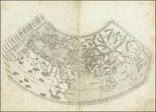
A Foundation Cartographic Document of the Renaissance (Martayan Lan)
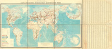
Nice untrimmed example of the earliest obtainable world map to attempt a modern geographical representation of the World.
Important early map of the World, which first appeared in the 1478 Rome edition of Ptolemy's Geography, Claudii Ptholomei Alexandrini. Cosmographia..., created under the direction of Conrad Swenheym (who apprenticed with Guttenberg), and published after Swenheym's death (1477), by Arnold Buckinck. The map is preceded by 3 other world maps, the small 1472 T-O map of Isidorus, the essentially unobtainable 1475 Rudimentum Novitorum and the essentially unobtainable 1477 Bologna edition of Ptolemy's World Map.
As noted by Nordenskiöld:
Until the 1477 edition was definitively dated, the (1478 Rome] edition was thought to be the oldest engraved atlas. It was printed by Arnoldus Buckinck, and is thought to be the only known book with his imprint. At first the engraving was supervised by a German, Conrad Sweynheym of Main (d. 1477). His method of using a printing press for the copperplate maps, together with the fine engraving, produced an excellent result. The text was edited by Domitius Calderinus of Verona; he collated various Latin manuscript in the translation by Jacobus Angelus with an ancient Greek Manuscript, which had been emended by Geirgius Gemistus (d. 1450). Calderinus was a careful worker, and his edition had been much admired for the correctness of the text, the fine typography and the brilliant engraving. Christopher Colombus owned a copy of [the Rome] edition, which he annotated. The run of the edition is not known, but it is considered to be scarce, and is therefore rare and important. ...
The map is preceded only by the Bologna edition of Ptolemy, first issued in 1477. As noted by Rodney Shirley:
The new copper plates engraved at Rome for the 1478 edition of Ptolemy's 'Geography' are much superior in clarity and craftsmanship to those of the Bologna edition. There is evidence that work on the Rome edition had been started in 1473 or 1474, and several of the plates may well have been engraved before those printed [by Taddeo Crivelli] at Bologna in 1477. . . . Many consider the Rome plates to be the finest Ptolemaic plates produced until Gerard Mercator engraved his classical world atlas of 1578.
Swenheym (and Arnold Pannartz) introduced the printing press to Italy at the height of the Renaissance, having been apprenticed to Guttenberg. Initially, under the enthusiastic patronage of Pope Paul II, Swenheym concentrated on publishing texts, but later turned to producing the first illustrated Cosmographia in the early 1470s, when enthusiasm was not sustained by the Pope's successor, Sixtus IV. The work was ultimately published one year after Swenheym's death in 1477. The plates for the 1478 Rome Ptolem were later purchased by Petrus de Turre in 1490, who published the second edition of the map.
Conrad Swehnheym's 1478 edition of Ptolemy's work is also of tremendous importance as the first set of maps to employ the "punched letter" printing process. As noted by Tony Campbell,
The development of lettering and numeral punches in fifteenth-century Italy, as a semi-mechanical alternative to the engraver's burin, marks a little-known point of contact between the histories of engraving and cartography. One of the unique features of a map is its necessarily dense toponymy, requiring the time-consuming skills of an experienced lettering engraver. Very early in the history of printed maps, indeed during preparation of the first set of maps to be engraved (if not quite the first to be published), punching was devised as a labour-saving alternative.
Conrad Sweynheym does not expressly claim responsibility for inventing punched lettering. But the dedication to the 1478 Rome edition of Ptolemy's Cosmographia (or Geographia), which appeared the year after his death, referred to the three years (i.e. 1474-77) during which, 'calling on the help of mathematicians, he gave instruction in the method of printing [the maps] from copper plates'. On this passage and the evidence of the engraved maps which Arnoldus Buckinck issued after Sweynheym's death, hangs the German-born printer's claim to a technique that would be used fairly widely on Italian maps for the next century or more.
Conrad Swenheym (Mainz), is widely thought to have been present at the birth of printing while an apprentice of Johann Guttenberg. After Mainz was sacked in 1462, Swenheym fled south to Italy and arrived at the Benedictine Monastery of Subiaco, at the suggestion of the great humanist and cartographer Cardinal Nicholas of Cusa. In 1464-5, Swenheyn and Arnold Pannartz introduced the first printing press to Italy. Over the next few years, Pope Paul II was to become so enthusiastic about the new medium that he liquidated scriptoria and commissioned several newly established printers to publish vast quantities of religious and humanist texts. In 1467, Swenheym and Pannartz moved to Rome under the Pope's patronage where they printed over fifty books from their press at the Massimi Palace. Unfortunately, when the pope died in 1471, the new pontiff Sixtus IV disavowed the numerous unpaid orders of his predecessor.
Swenheym and Pannartz elected to refocus there efforts on to creating the first printed illustrated edition of Ptolemy's Cosmographia, By 1474, Swenheym is recorded as having trained "mathematicians" to engrave maps on copper. Unfortunately, he did not survive to see the book's publication, but his contribution to the history of printing and map making places him at the highest level of importance in the evolution of the printed map.
Rarity
The map is rare on the market, with only a few examples having changed hands at auction or in dealer catalogs in recent decades.
The present example includes the full printed image of the map, which often appears with some portion trimmed off at an early date by the binder.
The 1478 and 1490 editions are identical, although there are different watermarks in the paper. There is some debate as to whether the watermarks are in fact completely reliable in determining the editions. The present example bears the date typically associated with the 1490 edition.
Claudius Ptolemy (fl. AD 127-145) was an ancient geographer, astronomer, and mathematician. He is known today through translations and transcriptions of his work, but little is known about his life besides his residence in Alexandria.
Several of his works are still known today, although they have passed through several alterations and languages over the centuries. The Almagest, in thirteen books, discusses astronomy. It is in the Almagest that Ptolemy postulates his geocentric universe. His geometric ideas are contained in the Analemma, and his optical ideas were presented in five books known as the Optica.
His geographic and cartographic work was immensely influential. In the Planisphaerium, Ptolemy discusses the stereographic projection. Perhaps his best-known work is his Geographia, in eight books. However, Ptolemy’s ideas had been absent from western European intellectual history for roughly a thousand years, although Arab scholars interacted with his ideas from the ninth century onward.
In 1295, a Greek monk found a copy of Geographia in Constantinople; the emperor ordered a copy made and the Greek text began to circulate in eastern Europe. In 1393, a Byzantine diplomat brought a copy of the Geographia to Italy, where it was translated into Latin in 1406 and called the Cosmographia. The manuscript maps were first recorded in 1415. These manuscripts, of which there are over eighty extant today, are the descendants of Ptolemy’s work and a now-lost atlas consisting of a world map and 26 regional maps.
When Ptolemy’s work was re-introduced to Western scholarship, it proved radically influential for the understanding and appearance of maps. Ptolemy employs the concept of a graticule, uses latitude and longitude, and orients his maps to the north—concepts we take for granted today. The Geographia’s text is concerned with three main issues with regard to geography: the size and shape of the earth; map projection, i.e. how to represent the world’s curve proportionally on a plane surface; and the corruption of spatial data as it transfers from source to source. The text also contains instructions as to how to map the world on a globe or a plane surface, complete with the only set of geographic coordinates (8000 toponyms, 6400 with coordinates) to survive from the classical world.
![[World Map with Portraits of Ferdinand Magellan, Willem Schouten, Francis Drake, Thomas Cavendish, Olivier van Noort and Joris van Speilbergen]](https://storage.googleapis.com/raremaps/img/small/90127.jpg)