|
||

|

|
|

|
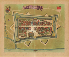
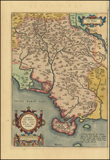
Map of Brescia and surrounding mountain and lake regions in Northern Italy, including Lago Di Garda. The map details the roads, pathways, lakes and mountains the Italian and French armies used to travel through the region.
The map includes notes explaining how Brixen is divided into five main parts including Val Canonica, Val Tropia, Val Sabio, Rivera de Salo, and Le Territoire. The notes describe the number of inhabitants, parishes and weapons in each location along with the type of environment, lands (cultivated and non-cultivated), and agriculture growing in each area. A scale of distance and a key of symbols denoting stongholds, chateau's, schools, chief places, waterways, and areas of battle is also included at the top right of the map.
Key strongholds are shown in Bergamo, Brescia, Soncino, Orci nuovi, Romano, Ponte Vico, Lonato, Caftiondelle stivere, Solferino, Afola, and near Lago d'Idro.
Published in Amsterdam circa 1700.
Pierre, or Pieter, Mortier (1661-1711) was a Dutch engraver, son of a French refugee. He was born in Leiden. In 1690 he was granted a privilege to publish French maps in Dutch lands. In 1693 he released the first and accompanying volume of the Neptune Francois. The third followed in 1700. His son, Cornelis (1699-1783), would partner with Johannes Covens I, creating one of the most important map publishing companies of the eighteenth century.
![[Manta, Italy] Manta Salutiarum March: Oppidum](https://storage.googleapis.com/raremaps/img/small/89096.jpg)