|
||

|

|
|

|
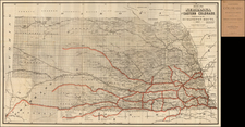
Nicolas King's Seminal Map of the Mississippi River, Based on the Observations of Zebulon Pike, Lewis & Clark, and Others
A remarkably important compilation forming a handsome map of the Mississippi River. It includes information from the Lewis & Clark expedition which pre-dates the release of their official account and map of the expedition.
East-oriented, the map traces the mighty Mississippi from the Missouri River in the south to the Leech Lake, which Pike identified as a source of the waterway. A striking eagle sits atop the map’s title, declaring these lands as American.
The map accompanied the first American edition of Zebulon Pike's important and influential An Account of Expeditions to the Sources of the Mississippi . . . . In preparing the map, Nicholas King brought together the best available sources from prior to the expeditions of Pike and Lewis & Clark, and added information furnished by Lewis and David Thompson (whose map for the Hudson’s Bay Company in 1798 is one of the most important pre-Lewis & Clark source maps).
The map was drawn by Nicholas King, whose post Lewis & Clark manuscript maps are among the earliest and most important to incorporate Lewis's reports. Pike's map, unlike Humboldt's, was based primarily on firsthand reconnaissance during his two expeditions in the American West.
Nicholas King was Surveyor for the City of Washington and unofficial cartographer to the Jefferson Administration (1800-1808). King prepared a series of maps at the request of Jefferson's War Department which represent "the earliest accurate geographical information of the west" (Ehrenberg). These were compiled from the notes and field sketches made by exploring parties sent out by Jefferson to investigate the vast region west of the Mississippi River following the Louisiana Purchase. The most famous of King's maps are the preliminary manuscripts he made of Lewis and Clark's discoveries and the engraved maps for publication in Zebulon Pike's journal. He was also responsible for the suppressed maps of the Red River associated with the Freeman & Custis Expedition of 1806 and the Map of the Washita river in Louisiana from the Hot Springs to the confluence of the Red River with the Mississippi from the Hunter & Dunbar Expedition of 1804.
The Lewis and Clark expedition
After President Thomas Jefferson completed the Louisiana Purchase, he wanted an expedition to explore and survey the vast lands that had come under the control of the United States. He chose Meriwether Lewis, an Army captain and Jefferson’s personal secretary, to lead the expedition. Lewis chose William Clark to lead with him. Clark was a land owner in Kentucky and an Army officer, where he had served with Lewis.
Both men studied extensively before setting out, reading up on medicine, botany, astronomy, and zoology. They read every available map and journal detailing the area, from Spanish, French, and British sources. Lewis gathered munitions at Harper’s Ferry, Virginia, and then boarded a custom-made keelboat, which he sailed down the Ohio River to Clarksville, Indiana, where he joined Clark. There, Clark boarded the boat, taking it up the Mississippi, while Lewis took to horseback to gather more supplies, including maps and surveying equipment.
Meanwhile, Clark recruited the men who would travel with them, members of the Corps of Volunteers for Northwest Discovery, at Fort DuBois, Missouri. The final group consisted of Lewis, Clark, Clark’s enslaved man, York, 27 soldiers, a French-Indian interpreter, and a boat crew. They set out on May 14, 1804, picking up Lewis in St. Charles, Missouri and continuing up the Missouri River. On August 20, Sergeant Charles Floyd died of stomach infection; miraculously, he was the only Corps member to die on the entire journey.
The Corps traveled through Iowa and into South Dakota. In November, they arrived near what is today Washburn, North Dakota, where they set up their winter camp. They built a structure they called Fort Mandan. Nearby were the Mandan and Minitari Indians, just some of the over fifty tribes who encountered Lewis and Clark on their journey. Some groups, like the Teton Sioux, were suspicious of the soldiers, but there was relatively little violence during encounters as compared to other similar expeditions.
At Fort Mandan, Sacagawea, a Shoshone woman, met Lewis and Clark. She was pregnant and with her husband, a French-Canadian fur trapper, Toussaint Charbonneau. Although the expedition hired Charbonneau as interpreter, it would be Sacagawea who would prove integral to the success of the venture. Sacagawea gave birth in February, 1805; the Corps set out, with baby Jean Baptiste in tow, in early April.
The Corps traveled across Montana, crossing the Continental Divide. They purchased horses from the Shoshone, thanks to Sacagawea. There, she also reunited with her brother, Cameahwait, whom she had not seen since she had been kidnapped by the Hidatsa people when she was 12; she was later sold to Charbonneau.
The horses proved useful as the Corps crawled over the Lolo Trail through the Bitterroot Mountains with Shoshone guides. Cold and exhausted, the men were revived by the Nez Perce Indians, who they met near the Clearwater River, in what is today Idaho. The final leg of their journey west was on the water; they rafted down the Clearwater to the Snake River, and then to the mighty Columbia.
They reached the Pacific Ocean in November of 1805. It was time for another winter camp, which they set up near what is today Astoria, Oregon. They called their shelter Fort Clatsop, moving in on Christmas Day. It was a damp and dismal winter, and practically the entire Corps had stomach sicknesses.
On March 23, 1806, the Lewis and Clark expedition headed east. They returned to the Nez Perce, where they had left their horses, then crossed the mountains. At the Lolo Pass, the leaders split their troops. Lewis headed to the Great Falls of the Missouri River; Clark and Sacagawea to the Yellowstone River. Clark named a large rock formation near the river Pompey’s Pillar; Pompey was the nickname for Sacagawea’s son.
Lewis had a less monumental time; they got into an altercation with Blackfeet warriors, killing two of them. This was the only episode that resulted in indigenous death during the expedition. Lewis’ woes continued, as he was shot in the buttocks soon thereafter.
The men and their groups reunited on August 12, 1806. They bid farewell to Sacagawea and her family at the Mandan villages. Then, they sailed down the Missouri River to St. Louis, where they arrived on September 23.
From Missouri, the leaders traveled to Washington D. C. to report on their findings. They had traversed over 8,000 miles, made a library of maps and accounts (nearly 5,000 pages of journals), returned 120 animal specimens and 200 botanical specimens, and did so with comparatively little violence.
Lewis became the Governor of the Louisiana Territory, while Clark was named Brigadier General of Militia for the Louisiana Territory and a federal Indian Agent. Unfortunately, Lewis became an alcoholic and died of gunshot wounds in 1809. Sacagawea died a few years later; Clark became the guardian of her children. Clark himself lived a successful life and died in 1838.
The publications of the Lewis and Clark expedition
The expedition was a huge success, widely reported upon in the papers of the time. Accounts of the journey were published even before they returned, however. Lewis’ and Clark’s letters were featured in periodicals from Boston to Louisville. Matthew Carey included a paragraph about the expedition in the 1806 edition of John Newbery’s Compendious History of the World (first published in London in 1763). Having received a cache of documents, Jefferson wrote a report to Congress in February 1806; portions of this were printed as broadsides and newspaper articles and then reprinted in whole by Hopkins and Seymour of New York, as well as in London and Natchez, Mississippi.
The first complete account of the expedition came out of Pittsburgh, Pennsylvania. Zadok Cramer saw an opportunity; he purchased the journal of Patrick Gass, a Corps member, and flew the journal through printing. Cramer and his partner, David M’Keehan, released the book less than a year after the return of the Corps; they sold their publication rights to J. Budd (London) and Matthew Carey (Philadelphia); the latter published three illustrated editions of the journal.
In 1809, the pseudonymous Hubbard Lester penned a fictitious account that borrowed liberally from other sources. His work included a bogus map riddled with errors. Over the next fifty years, at least eight fictitious or counterfeit Lewis and Clark accounts were offered to readers. The last one appeared in 1846, showing that even these fraudulent accounts found an audience.
More discerning readers had to wait until 1814 for the authorized expedition account. Nicholas Biddle and Paul Allen compiled an abridged version of Lewis and Clark’s journals into a two-volume narrative. Lewis was supposed to have written the account, but his decline and death in 1809 made this impossible. The account also included a detailed map of the American West by Clark, which would remain the gold standard for the northwestern United States until the 1830s.
However, many critics found the lack of a volume dedicated to the botanical and naturalist findings a major detraction of the work. It seems that many Americans already knew the story of the expedition; they wanted more figures, images, and data. This is supported by the fact that most surviving examples of the Biddle/Allen account lack the map; there is some evidence that travelers used it for trans-Mississippi journeys. The Biddle/Allen narrative was printed in many languages worldwide, but it was only reprinted in the US once, in 1842.
The western expeditions of Zebulon Pike
Zebulon Pike was born in 1779 in New Jersey; his father was an officer in the Continental Army during the American Revolution. A teenage Zebulon followed in his footsteps, joining the army after being raised on a series of western outposts. One of his first assignments was to trail the French expedition under General Georges Henri Victor Collot, which was mapping the Mississippi frontier.
Following the Louisiana Purchase, President Thomas Jefferson needed to know more about the vast swath of land he had purchased, as well as extend American sovereignty into an area that already contained French, British, and Spanish trappers and traders. Additionally, he needed to create new treaties and relationships with the Indigenous peoples. To achieve these aims, Jefferson ordered several expeditions into the American West, including the Lewis and Clark expedition and what are now known as the first and second Pike expeditions.
Initially, Lieutenant Pike was charged with the command of a reconnaissance expedition to find the source of the Mississippi River. Pike’s mission left St. Louis on April 9, 1805 with orders to expel fur traders operating illegally within US borders, to establish cordial relations with several powerful tribes, and to survey the Mississippi and its tributaries. They set off upstream and reached the convergence of the Mississippi and the Minnesota Rivers in September. There, Pike purchased land from the Dakota people which would become Fort Snelling. They camped at the mouth of the Swan River and then continued north on the frozen waterway to contact British North West Company fur posts.
The farthest north they reached was Leech Lake. Pike told the traders there that they were now under US jurisdiction and he struck the British flag from the site. He also met with Ojibwe leaders. Pike thought that the nearby Upper Red Cedar Lake might be the upper source of the Mississippi and conducted latitude readings there. The American travelers headed south at the end of February 1806. They returned to St Louis on April 20, the first of the government’s western expeditions to return.
Only ten weeks later, Pike was off again, this time to the southwest. He was to map the headwaters of the Arkansas and Red Rivers, as well as to survey the southwestern Louisiana Territory. Pike and his men left on July 15, 1806. By November, they were in what is today Colorado. They attempted to climb the tallest elevation they had seen thus far; although he never scaled it, the mountain is now known as Pike’s Peak, one of the most famous geographic features in the Continental United States.
From Colorado the group turned south, which brought them into Spanish territory. They were seized by Spanish soldiers and brought to Santa Fe to be interrogated and detained. From there, they journeyed to Chihuahua state in Mexico, where they stayed for several months. Pike’s papers were seized. However, he was allowed to socialize with the officers and learned much about the state of affairs and politics in what was then New Spain. He took new notes and smuggled these out in the gun barrels of his men. The US and Spain were at peace during this time; therefore, Pike and his men were escorted from Spanish holdings via San Antonio to the American border in early July.
Pike would go on to serve in the War of 1812, where he was promoted to the rank of brigadier general. He died fighting at the Battle of York in April 1813.
The seizure of his journals did not seem to faze Pike, who wrote a stirring account of his adventures, with the part on the second expedition drawn mainly from memory. This was published in 1810 as An Account Of Expeditions To The Sources Of The Mississippi, And Through The Western Parts Of Louisiana. The narrative proved popular and was quickly released in Dutch, French, and German editions. It was a must-read for explorers and settlers of the American West until well into the twentieth century.
Pike provided some of the first descriptions of the American West—especially of Texas, Colorado, and New Mexico—to the reading public. For example, the section on Texas is the first to describe the area in detail in English. His is one of the most important books on western exploration and one of the pillars of Western Americana.
Pike also produced several maps to accompany the account which are very influential in the history of American cartography. These were the first maps of the Louisiana Territory to be based on first-hand observations. His map of New Spain was based on Humboldt’s, although the latter was not published until a year later. All of Pike’s maps were foundational for later cartographers and are some of the earliest western maps produced in the still-growing United States.
![Carte Qui Contient La Maniere Dont Se Fait La Chasse Des Bouefs Sauvages . . . [Buffalo, Niagara Falls, Calumet Village, Huron & Illinois Indians]](https://storage.googleapis.com/raremaps/img/small/93146.jpg)