![[DeWitt Clinton Copy] An Account of Expeditions to the Sources of the Mississippi, and through the Western Parts of Louisiana, to the Sources of the Arkansaw, Kans, La Platte, and Pierre Jaun, Rivers During the years 1805, 1806 and 1807. And a Tour through the Interior Parts of New Spain. in the year 1807. By Zebulon Montgomery Pike](https://storage.googleapis.com/raremaps/img/small/81745.jpg)


|
||

|

|
|

|
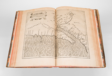
Excellent Presentation of the Maps of the Pike Expedition, Prepared Contemporaneously as an Atlas. With Frederick Remington's Bookplate.
In 1807 Pike led one of the earliest expeditions to reconnoiter the newly purchased territory of Louisiana. His expedition resulted in a series of maps that are very important for the Mississippi River, the Transmississippi West, and Texas.
In Texas, Pike's maps provide a significant improvement in rendering the interior. With the exception of the lower courses of the Sabine and Neches, which are distorted to the East, the Rivers are shown accurately. The Brazos is, for the first time in a printed map, shown in almost its proper length and shape.
The atlas includse the following maps:
- Falls of St. Anthony
- Map Of The Mississippi River From Its SOurce to the Mouth of the Missouri
- The First Part of Captn. Pike's Chart of the Internal Parts of Louisiana
- A Chart of the Internal Part of Louisiana
- A Map of The Internal Provinces of New Spain.
- A Sketch of the Viceroyalty Exhibiting the several Provinces and its Approximation to the Internal Provinces of New Spain.
The atlas is bound in contemporary quarter calf over blue boards, with onlaid lettering piece "PIKE | EXPEDITION." Backstrip worn through.
![[ World Atlas -- Rare Late Edition ] Carey's General Atlas. Improved and Enlarged: Being a Collection of Maps of the World and Quarters, Their Principal Empires, Kingdoms, &c.](https://storage.googleapis.com/raremaps/img/small/102646.jpg)
![[ Tracking The Armies of Bonaparte and the English During The Peninsular Campaign ] New Map of Spain and Portugal By E. Mentelle, Member of Institute of Science at Paris, and P. G. Chanlaire, One of the Authors of the National Atlas](https://storage.googleapis.com/raremaps/img/small/99148.jpg)
![[Untitled American School Atlas]](https://storage.googleapis.com/raremaps/img/small/98891.jpg)