|
||

|

|
|

|
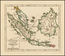
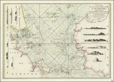
The First Admiralty Charting of the Singapore Strait
Important early chart of the Eastern portion of the Strait of Singapore, published by the British Admiralty, based upon the surveys of John Turnbull Thomson.
The chart extends from the mouth of the Johore River and the eastern tip of Singapore Island and Tekong Island to the northern parts of Battam and Bintang Islands.
Thomson arrived in the Malay Straits in 1838 and was employed by the East India Survey. In 1841 he was appointed Government Surveyor at Singapore and in 1844 became Superintendent of Roads and Public Works. He was responsible for the design and construction of a number of notable engineering works including bridges, roads, and hospitals. He conducted the allotment survey of Singapore, the topographical survey of the island of Singapore and its dependencies, and the marine survey of the Strait of Singapore and the east coasts of Johore and Penang. His outstanding achievement was the erection of the Horsburgh Lighthouse on Pedra Branca.
In 1853 his health failed and he returned to England where he studied modern engineering techniques, and travelled widely through Britain and the Continent inspecting engineering works. Early in 1856 he emigrated to New Zealand, where he worked as Chief Surveyor of the Otago Province until 1873. From 1876 until 1879 he was Surveyor-General of New Zealand.
John Turnbull Thomson's hydrographic survey was the first detailed hydrographic survey to be conducted by a locally based surveyor and is the most important and detailed early hydrographic map of the Singapore Strait. The first chart created by this survey was compiled by Captain Samuel Congalton and John Turnbull Thomson during Turnbull's 12 years as government surveyor in the Straits Settlement and delivered to the merchant trade the first accurate and reliable charting of what would become one of the most trafficked waterways in the world. This first chart was a privately printed 2 sheet chart of the Strait, first published in London by Richardson Brothers on August 17, 1846, with a later edition updated to 1855.
The present chart (one of a set of three charts) was the first Admiralty Chart of the region, issued in November 1855, incorporating the information from the revised edition of the Congalton.
Rarity
The chart is very rare. We note only an earlier example in the British Library (1856) and a later example (1866) in the collection of the National Maritime Museum at Greenwich.
The British Admiralty has produced nautical charts since 1795 under the auspices of the United Kingdom Hydrographic Office (HO). Its main task was to provide the Royal Navy with navigational products and service, but since 1821 it has also sold charts to the public.
In 1795, King George III appointed Alexander Dalrymple, a pedantic geographer, to consolidate, catalogue, and improve the Royal Navy’s charts. He produced the first chart as the Hydrographer to the Admiralty in 1802. Dalrymple, known for his sticky personality, served until his death in 1808, when he was succeeded by Captain Thomas Hurd. The HO has been run by naval officers ever since.
Hurd professionalized the office and increased its efficiency. He was succeeded by the Arctic explorer Captain William Parry in 1823. By 1825, the HO was offering over seven hundred charts and views for sale. Under Parry, the HO also began to participate in exploratory expeditions. The first was a joint French-Spanish-British trip to the South Atlantic, a voyage organized in part by the Royal Society of London.
In 1829, Rear-Admiral Sir Francis Beaufort was appointed Hydrographer Royal. Under his management, the HO introduced the wind force scale named for him, as well as began issuing official tide tables (1833). It was under Beaufort that HMS Beagle completed several surveying missions, including its most famous voyage commanded by Captain FitzRoy with Charles Darwin onboard. When Beaufort retired in 1855, the HO had nearly two thousand charts in its catalog.
Later in the nineteenth century, the HO supported the Challenger expedition, which is credited with helping to found the discipline of oceanography. The HO participated in the International Meridian Conference which decided on the Greenwich Meridian as the Prime Meridian. Regulation and standardization of oceanic and navigational measures continued into the twentieth century, with the HO participating at the first International Hydrographic Organization meeting in 1921.
During World War II, the HO chart making facility moved to Taunton, the first purpose-built building it ever inhabited. In 1953, the first purpose-built survey ship went to sea, the HMS Vidal. Today, there is an entire class of survey vessels that make up the Royal Navy’s Hydrographic Squadron. The HO began to computerize their charts in the late 1960s and early 1970s. In 1968, the compilation staff also came to Taunton, and the HO continues to work from there today.
![[ Philippine Islands & Spice Islands ] Isles Philippines et Moluques . . .](https://storage.googleapis.com/raremaps/img/small/99646.jpg)