
The item illustrated and described below is sold, but we
have another example in stock. To view the example which
is currently being offered for sale, click the
"View Details" button below.


|
||

|

|
|

|
Stock# 56341
Description
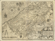
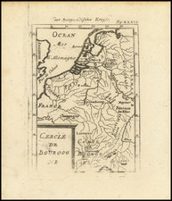
Fine early map of Flanders, published in Antwerp by Gerard De Jode.
The map is based upon an earlier Italian map by Tramezzini. Oriented with North at the top, the map is embellished with multiple coasts of arms, an elaborate compass rose with 32 wind directions and 4 bears holding flags.
![[Course of the Rhine River] Nova Tractus Totius Rheni Oder Neue beschreibung des Rhein-Strom](https://storage.googleapis.com/raremaps/img/small/58670.jpg)
![[Dunkerque] Pascaert vande Custe van Vlaenderen, van Walcheren tot Cales en Bouloigne in Vranckrijck](https://storage.googleapis.com/raremaps/img/small/79940.jpg)