


|
||

|

|
|

|
Stock# 56179
Description
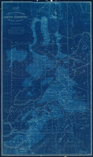
Fine regional map of Southeastern Idaho, based upon reconnaissance done in the Wheeler Survey Expedition of 1877, "Atlas sheet No. 32 (D) U.S. Geological surveys west of the 100th Meridian. Expedition of 1877 under command of 1st. Lieut. Geo. M. Wheeler. Corps of Engineers, U.S. Army."
Centered on Soda Springs, the map locates the Mormon Salt Works, Georgetown, Bennington, Red Rock Pass, the Nine Mile Settlement and the Elkhorn Mail Station.
The map includes portions of the Snake and Bear River drainage, the latter tributary to the Great Salt Lake Basin.
![[ Western United States -- Massive Idaho Territory ]](https://storage.googleapis.com/raremaps/img/small/99057.jpg)
![Map of Oregon Territory. By Samuel Parker. 1838. [with:] Journal of an Exploring Tour Beyond the Rocky Mountains, under the direction of the A. B. C. F. M. 1840.](https://storage.googleapis.com/raremaps/img/small/97939.jpg)