The item illustrated and described below is sold, but we
have another example in stock. To view the example which
is currently being offered for sale, click the
"View Details" button below.


|
||

|

|
|

|
Stock# 56175
Description
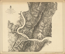
Fine example of this scarce large format plan of the battlefield and area around Harper's Ferry, West Virginia.
Extends south to Waldror's School House, east to Tellgate and the Charleston Turnpike and Shenandoa River, West to the South Mountains. Centered on Fort Duncan.
What is most noteworthy about the map is the inclusion of dozens of land owners on the map. Also shows roads, bridges, railroads, etc. Scale of 3 inches to 1 mile.
Reference
Stephenson 597.6.