|
||

|

|
|

|
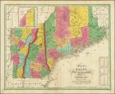
Finely engraved map of xxxxxxxxxxxxxxxxxxxxxxxxxxxxxxxxxxxxxx during the American Revolution.
Originally engraved by Bernard Romans in New Haven, Connecticut, in 1778, the map is one of the rarest maps of the American Revolutionary War period. This edition of the map was issued by the Amsterdam firm of Covens & Mortier, based closely on one published by Bernard Romans in New Haven, Connecticut in 1778.
Bernard Romans
Bernard Romans was born in Delft, Netherlands about 1720. He learned mapmaking and surveying in England, before moving to the Colonies in 1757. He served as a Surveyor in Georgia, where he would rise to become Deputy Surveyor General in 1766 and one of the most important Colonial mapmakers. He is perhaps best known for his extensive survey and mapping or the Coastal Waters of East Florida. William Gerard De Braham, the Surveyor General for the Southern Colonies appointed him Deputy Surveyor General for the Southern District in 1773 and wrote A Concise Natural History of East and West Florida, published in 1775, one of the most important works on Florida.
When war broke out in 1775, Romans was in Boston where Paul Revere was engraving Romans' maps of Florida. Romans enlisted in the American cause and was appointed a Captain and served with Benedict Arnold and Nathaniel Greene in their attacks on Fort George and Fort Ticonderoga. Following the Battle of Bunker Hill, Romans publishe d An Exact View of the Late Battle of Charleston, June 17, 1775 and a map of the area around Boston, entitled The Seat of War In America, which he dedicated to John Hancock.
Romans served until June 1778, when he resigned his commission. He rejoined the Southern Campaign in 1780, during which time he was captured by the Royal Navy and imprisoned until the end of the War. He died returning home after the War in 1784 (one account put forth by his family is that he was murdered and thrown overboard).
Romans published several other significiant maps of the American Revolution in New Haven, each of which is essentially unobtainable. In 1778 Romans advertised for sale A Chorographical Map of the Northern Department of North America and A Chorographical Map of the Country Round Philadelphia. He also published Connecticut and parts adjacent, with Abel Buell.
The appearance of three of the Romans maps in editions published in Amsterdam shortly after the publication of the original New Haven versions of the map is a topic worthy of investigation. It is reasonable to speculate that Romans used his Dutch roots to have a set of the maps sent back to Amsterdam for publication
Rarity
The original Romans map is essentially unobtainable. xxxx

![[Last of the Mohicans / New York] Carte dressee pour la lecture du Dernier des Mohicans Roman de J. Fenimore Cooper](https://storage.googleapis.com/raremaps/img/small/86045.jpg)
![[Lake Champlain] Map of the County of Clinton By David H. Burr](https://storage.googleapis.com/raremaps/img/small/80723.jpg)