
This item has been sold, but you can enter your email address to be notified if another example becomes available.


|
||

|

|
|

|
Stock# 56029
Description
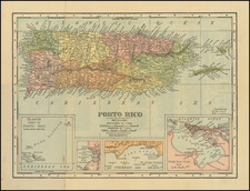
Detailed map of Puerto Rico, prepared by the Adjutant General's Office, Military Information Division.
The map includes significant Topographical material, roads,and many place names. The key identifies:
- US Forces (American Flag)
- Spanish Forces (Red Flag)
- lines of the US March shown in red
- the lines of the US Reconnaissance shown in dashed red lines.
- USD Militarty Telegraph and Telephone stations
- Towns Occupied by the US troops and scouting parties
- Campsites
- Battle sites.
Chains of commands shown at top. Inset shows islands of Culebra and Vieques.
The map is scarce. This is the first tme we have offered it for sale.
Condition Description
Minor fold discoloration.
![Cuba Insula [with] Hispaniola Insula [with] Insula Jamaica [with] Ins. S. Ioannis [with] I.S. Margareta Cum Confiniis](https://storage.googleapis.com/raremaps/img/small/95802.jpg)

![[ Virgin Islands ] Anguilla to Porto Rico Shewing the Approaches to the Virgin Islands](https://storage.googleapis.com/raremaps/img/small/86323.jpg)