|
||

|

|
|

|
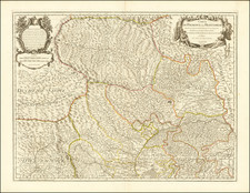
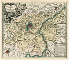
A fine example of Pierre Mortier's map of the Lombardy region centered on Bergamo in Northern Italy.
Notes in the lower left corner of the map explain the details of French and Imperialist squads within the moutainous regions of Northern Italy. Included in the notes are the number of inhabitants, mules, cows, horses, and amount of gold at each of the main locations.
Main encampments such as Bergamo, Cluson, Calepio, Martinengo, and Romano or colored in red. Lago Di Como and Lago De Spino are featured on the map along with many small towns, rivers, and paths.
The map includes both a key and a scale of distance to the French, German and Italian communes in the lower right corner.
Published in Amsterdam, circa 1700.
Pierre, or Pieter, Mortier (1661-1711) was a Dutch engraver, son of a French refugee. He was born in Leiden. In 1690 he was granted a privilege to publish French maps in Dutch lands. In 1693 he released the first and accompanying volume of the Neptune Francois. The third followed in 1700. His son, Cornelis (1699-1783), would partner with Johannes Covens I, creating one of the most important map publishing companies of the eighteenth century.
![[Vercelli] Urbis Vercellensis a Carolo Emmanuele II](https://storage.googleapis.com/raremaps/img/small/89098.jpg)