


|
||

|

|
|

|
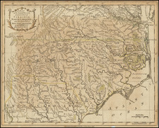
Nice detailed map of the Gulf Coast from Pensacola to the mouth of the Mississippi River, from the February 1772 edition of Gentleman's Magazine, with a nice inset plan for a New Settlement.
Extends to west of New Orleans to include Plantations along the Iberville at its confluence with the Mississippi. Also names Biloxi and a number of islands, rivers, etc.
The map shows the coastline at a time when the English controlled the region, although the Spanish were actively allied with the Indians in the regions plotting to retake the region.
The Gentleman’s Magazine was a British publication that helped to normalize the use of maps in support of articles and features. It was founded in 1731 by the prominent London publisher Edward Cave, a pioneer in periodical journalism. The magazine continued in print for nearly two centuries, shuttering production in 1922.
This was the publication which first used the word “magazine”, from the French for storehouse. Cave wanted to create a storehouse of knowledge and he employed some of London’s best writers to fill his pages: Samuel Johnson gained his first regular employment by writing for the Gentleman’s Magazine. Other famous contributors included Jonathan Swift.
The publication covered a broad range of topics, from literature to politics, and, from 1739, frequently used maps as illustrations. The first map they printed was a woodcut of Crimea; the second was a fold-out map of Ukraine by Emanuel Bowen. Maps were used to show battle lines, to chronicle voyages, and to educate about areas with which Britain traded. Certain geographers, like Thomas Jefferys, contributed several maps to the publication.

![[Florida Indians / Hermaphrodites] Hermaphroditorum officia. XVII.](https://storage.googleapis.com/raremaps/img/small/97966.jpg)
![[Florida Keys, Cuba, Bahamas, Cayman Islands] The Island of Cuba with part of the Bahama Banks & the Martyrs . . .](https://storage.googleapis.com/raremaps/img/small/85166.jpg)