|
||

|

|
|

|
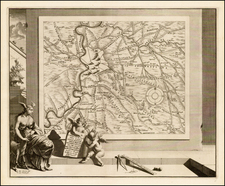
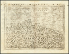
A fine example of Pierre Mortier's map of the Lombardy region centered on Cremasco (Crema) in northern Italy.
The map includes a cartouche and scale of distance between the five main dwellings of the region including Chiari, Romano, Soncino, Crema and Lodi. It also notes the military positions of the French, Italian and Germans.
Wooded areas are indicated with small trees.
Published in Amsterdam circa 1700.
Pierre, or Pieter, Mortier (1661-1711) was a Dutch engraver, son of a French refugee. He was born in Leiden. In 1690 he was granted a privilege to publish French maps in Dutch lands. In 1693 he released the first and accompanying volume of the Neptune Francois. The third followed in 1700. His son, Cornelis (1699-1783), would partner with Johannes Covens I, creating one of the most important map publishing companies of the eighteenth century.
![[Manta, Italy] Manta Salutiarum March: Oppidum](https://storage.googleapis.com/raremaps/img/small/89096.jpg)