|
||

|

|
|

|
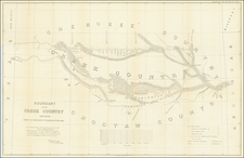
An exceptional map of the region between Omaha, Nebraska and the Pacific Ocean, illustrating the actions of the US Cavalry during the Nez Perce indian Campaign.
The map illustrates the retreat of the Nez Perce Indians in the winter of 1877. It identifies forts, battle sites, trails, direction of troop movements, etc. In the face of relentless pursuit of the troops under General Howard, Chief Joseph and his small band (less than 500 people counting women and children) fought one of the most extraordinary Indian Wars in American history.
The map includes notes and views of important places, records their retreat through the Bitterroot Mountains, twice across the Rocky Mountains, through Yellowstone National Park, across the Missouri River to the Bear Paw Mountains. The Nez Perce finally surrendered on Eagle Creek, only 30 miles from their destination.
The seven views along the bottom show various fights and battles plus an inset map titled "Scene of the Outbreak."
![[Southwest Riverside County] Elsinore Quadrangle](https://storage.googleapis.com/raremaps/img/small/83490.jpg)
![[Southern California] Map of Automobile Roads Banning California](https://storage.googleapis.com/raremaps/img/small/45357.jpg)