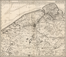
|
||

|

|
|

|
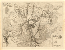
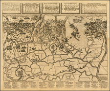
Battle Plan of The Siege of Namur in 1695
Rare Battle Plan showing the lines of for forces of King William III during his siege o the City and Castle of Namur.
The view shows the lines during the Second Siege of Namur, which resulted in the retaking of Namur from the French in 1695. The first Siege of Namur in 1692 had resulted in the French taking of this important city.
The view shows the City of Namur, separated from its well fortified Castle by the Sambre River. During the sieges, the city itself would quickly fall in each instance to the attackers, whereas the strongly fortified castle would remain besieged for nearly a month, before falling.
The map shows the Allied powers under King William III arrayed around the City. At the far left is the King's Quarter flanked on either side by the Bavarian allies under Maximillian of Bavaria. Similarly, at the top right, the King's Quarter (William III) is shown, with the Brandenbourg forces on the west side of the Meuse (Maas) River.
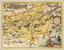
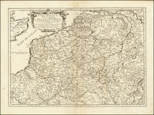
The Siege of Namur
The city of Namur found itself under siege on two occasions during the Nine Years War.
The first siege occurred from May 25 to June 30 1692 and was a major engagement of the Nine Years' War. The Siege was part of the French grand plan to defeat the forces of the Grand Alliance and bring a swift conclusion to the war. Namur, sitting on the confluence of the Meuse and Sambre rivers, was a considerable fortress, and was a significant political and military asset. French forces, guided by Vauban, forced the town's surrender on June 5, but the citadel, staunchly defended by Menno van Coehoorn, who managed to hold on until June 30, before capitulating, bringing an end to the 36-day siege. Concerned that King William III planned to recapture the stronghold, King Louis XIV subsequently ordered his commander-in-chief, the duc de Luxembourg, to join battle with the Allies in the field, resulting in the bloody Battle of Steenkerque on August 3, 1692.
Following the French taking of Namur, the re-taking of the City by King William III was a constant threat. Namur was divided into the 'City' containing residential and commercial areas and the Citadel controlling access to the Sambre and Meuse rivers. In 1692, the Dutch military engineer Menno van Coehoorn had made the Citadel one of the strongest defensive points in Flanders.
Namur's defenses had been significantly upgraded by Vauban since 1692 while Boufflers had a garrison of 13,000, making it a formidable challenge. During July, 1695 the Allies of King William III battered their way into the City, with both sides incurring heavy casualties. By early August the French had lost half their men in the battle for the outer defenses and could not repulse another assault. On August 3, 1695 the governor of Namur Count Guiscard surrendered the City to Maximilian of Bavaria and asked for a truce to allow the French to withdraw to the Citadel.[ his was accepted and the siege resumed after six days.
Vaudémont's task was keeping his army between Villeroi and Namur; Villeroi tried to tempt him out of position by attacking Allied-held towns like Knokke and Beselare, now Zonnebeke).[f] Vaudémont refused to be drawn; both sides knew the longer the siege went on, the more likely Namur was to fall and the Allies were happy for Villeroi to spend time besieging places like Knokke. Villeroi's attempt were unsuccessful, despite the capture of Diksmuide and Deinze in late July with 6,000 - 7,000 prisoners and the Bombardment of Brussels in August that destroyed large parts of the commercial center.
By mid-August, the Citadel was still largely intact while Villeroi's activities made resupply much more difficult. Coehoorn and William now agreed a new approach. A battery of 200 guns was established in Namur city and on August 21, 1695 began a continuous 24 hour bombardment of the Citadel's lower defenses. Boufflers later told Louis it was ‘the most prodigious artillery ever assembled' and by August 26, the invaders were ready to assault the Citadel. At midnight on the 27th, Villeroi finally made contact with Vaudémont but his numerical advantage was offset by their strongly entrenched positions. Having failed to outflank the Dutch Allied lines, Villeroi retreated and William gave the order for a general assault.
The assaults by the Allies were extremely bloody. By September 2, 1695, Count Guiscard now commanding the key outwork of Fort Orange told Boufflers they could not repulse another attack; the garrison surrendered on September 4.
Pierre, or Pieter, Mortier (1661-1711) was a Dutch engraver, son of a French refugee. He was born in Leiden. In 1690 he was granted a privilege to publish French maps in Dutch lands. In 1693 he released the first and accompanying volume of the Neptune Francois. The third followed in 1700. His son, Cornelis (1699-1783), would partner with Johannes Covens I, creating one of the most important map publishing companies of the eighteenth century.