|
||

|

|
|

|
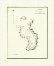
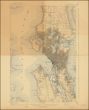
Rare engraved thick paper edition of the USCS chart of the Coast of Washington, from Gray's Harbor to the Straits of Juan de Fuca and up the Straits to the area around Whidbey Island,
The map includes 4 large profile views of:
- Cape Flattery area
- Flattery Rocks
- Destruction Island
- Pt. Grenville
While the normal examples on thin paper appear on the market with some frequency, the map is quite rare in this thick paper, unfolded state.
The United States Office of the Coast Survey began in 1807, when Thomas Jefferson founded the Survey of the Coast. However, the fledgling office was plagued by the War of 1812 and disagreements over whether it should be civilian or military controlled. The entity was re-founded in 1832 with Ferdinand Rudolph Hassler as its superintendent. Although a civilian agency, many military officers served the office; army officers tended to perform the topographic surveys, while naval officers conducted the hydrographic work.
The Survey’s history was greatly affected by larger events in American history. During the Civil War, while the agency was led by Alexander Dallas Bache (Benjamin Franklin’s grandson), the Survey provided the Union army with charts. Survey personnel accompanied blockading squadrons in the field, making new charts in the process.
After the Civil War, as the country was settled, the Coast Survey sent parties to make new maps, employing scientists and naturalists like John Muir and Louis Agassiz in the process. By 1926, the Survey expanded their purview further to include aeronautical charts. During the Great Depression, the Coast Survey employed over 10,000 people and in the Second World War the office oversaw the production of 100 million maps for the Allies. Since 1970, the Coastal and Geodetic Survey has formed part of the National Oceanic and Atmospheric Administration (NOAA) and it is still producing navigational products and services today.
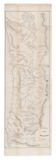
![Map of Oregon, Washington and Part of Idaho [First Appearance Of Idaho Territory, including western Montana and Western Wyoming]](https://storage.googleapis.com/raremaps/img/small/94211.jpg)