
This item has been sold, but you can enter your email address to be notified if another example becomes available.


|
||

|

|
|

|
Stock# 55719
Description
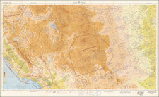
Detailed map of the State of Nevada, published by the General Land Office.
The map identifies County Boundaries, US Surveyor offices, US Land Offices, Indian Reservations, National Forests and Bird Reservations.
Includes large town plans for Carson City, Tonopah, Reno, Winnemucca, Elko, Ely and Goldfield & Columbia.
One of the most detailed maps of Nevada of the period.
![California [with large inset of Utah and Part of New Mexico]](https://storage.googleapis.com/raremaps/img/small/92004.jpg)
![[ Idaho Below Montana ] Verein-Staaten am Stillen Ocean… [inset of San Francisco Bay] [Unusual Idaho & California configurations]](https://storage.googleapis.com/raremaps/img/small/99297.jpg)
![[The Indian Tribes of California] Karte Übersicht zur Verbreitung der Indianer-stämme in Kalifornien](https://storage.googleapis.com/raremaps/img/small/96549.jpg)
![[Nevada and parts of California, Utah and Arizona] Explorations and Surveys South of Central Pacific R.R. . . . Preliminary Topographical Map Map Embracing in Skeleton a Portion Only of the Notes from Surveys . . . 1871 (with original text)](https://storage.googleapis.com/raremaps/img/small/82964.jpg)