This item has been sold, but you can enter your email address to be notified if another example becomes available.


|
||

|

|
|

|
Stock# 55673
Description
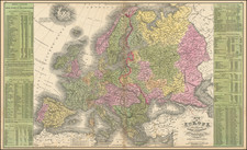
Attractive map of Europe, colored by countries.
The map is drawn before the final dismemberment of Poland.
Robert Wilkinson was active in London as a cartographic publisher from 1785 to 1825. He produced a number of nice works, including a General Atlas and a re-issuance of Bowen & Kitchen's English Atlas, along with excellent large format separate maps.
Condition Description
MInor soiling in teh upper left maring
![[Course of the Rhine River] Corso del Reno Parte Septentrio [and] Corso del Reno Parte Meridionale . . . 1690](https://storage.googleapis.com/raremaps/img/small/73095.jpg)
![Nova Europae Descriptio [Carte-a-figures]](https://storage.googleapis.com/raremaps/img/small/80435.jpg)
![[Ancient and Modern German Empires] Carte de la Germany et les Diferents Etats ou ses Peuples ont Porte Leurs Conquestes](https://storage.googleapis.com/raremaps/img/small/78195.jpg)