
This item has been sold, but you can enter your email address to be notified if another example becomes available.


|
||

|

|
|

|
Stock# 55286
Description
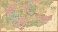
Attractive county map of England and Wales, showing towns, rivers, lakes, islands, etc.
Robert Wilkinson was active in London as a cartographic publisher from 1785 to 1825. He produced a number of nice works, including a General Atlas and a re-issuance of Bowen & Kitchen's English Atlas, along with excellent large format separate maps.
![[Saxon Britain] Britannia Saxonica](https://storage.googleapis.com/raremaps/img/small/85220.jpg)
![[England, Scotland & Wales]. Parte Settentrionale del Regno d'Inghilterra . . . (with) Parte Meridionale del Regno d'Inghilterra . . .](https://storage.googleapis.com/raremaps/img/small/89516.jpg)
![[Wall Map of England] England and Wales Drawn from the most accurate Surveys . . . . By John Rocque](https://storage.googleapis.com/raremaps/img/small/56438.jpg)