|
||

|

|
|

|
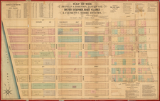
Rare separately published map of Kings and Queens Counties, from Brooklyn to Oyster Bay.
The promotional material includes advertising and vignettes for several businesses and a Brooklyn City Reference Table and map Index.
The map includes numerous inset town plans, including:
- Coney Island
- Rockaway Beach
- Richmond Hill
- Hollis
- Long Island City
- Morris Park
- Spa Cliff / Town of Oyster Bay
- Bath
- Cedarhurst
- Sheepshead Bay
The map covers the present-day borough of Brooklyn (Kings County, New York City) and the entire pre-1899 area of Queens County. Also covers Nassau County which was formed from the eastern part of Queens County in 1899.
Shows incorporated cities, towns (townships), numbered districts, roads, rural buildings, and rural householders' names; shows street systems in urban areas.
Includes a 1-mile radial distances from N.Y. City Hall (Manhattan).
Rarity
OCLC locates one copy -- Library of Congress.
![[Harlem]. Map of the Harlaem Commons surveyed agreeably to the boundaries established by the Commissioners appointed to settle the boundary lines between the common lands of the City of New York and the Town of Harlaem...](https://storage.googleapis.com/raremaps/img/small/59385.jpg)
![(Viele Water Map - Early Facsimile) Sanitary & Topographical Map of the City and Island of New York. Report of the Council of Hygiene and Public Health of the Citizens Association of New York Upon the Sanitary Condition of the City [with map:] Sanitary and Social Chart of the Fourth Ward of the City of New York](https://storage.googleapis.com/raremaps/img/small/103581.jpg)