|
||

|

|
|

|
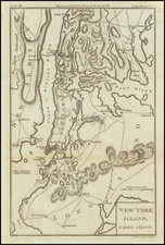
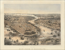
Revolutionary War Era Map of New York City and Environs
Fine early map showing area around Manhattan Island, western Long Island and part of Westchester County, which appeared in the London Magazine in 1778.
The map illustrates the Revolutionary War campaign in the region, showing the military encampments in Upper Manhattan.
The English city of New York has moved north toward what is now City Hall Park, with recent growth in the population up the Bowery, then a major highway leading toward the Eastern or Boston Post Road. During the entire period of the American Revolution, New York was occupied by British troops.
Hell-Gate is a focal point of the map, with arrows pointing out the circuitous "ship course" for safe passage. Adrian Block, the Dutch explorer, named Helegat or Hell-Gate when he sailed his Tyger through it in 1612. Thousands of vessels were lost in its unusual tidal currents, generated by a ledge of rocks projecting into the water from Long Island.
Thomas Kitchin was a British cartographer and engraver. Born in Southwark, England, Kitchin was the eldest of several children. He was apprenticed to the map engraver Emanuel Bowen from 1732 to 1739, and he married Bowen’s daughter, Sarah, in December 1739. By 1741 Kitchin was working independently and in 1746 he began taking on apprentices at his firm. His son Thomas Bowen Kitchin was apprenticed to him starting in 1754. By 1755 Kitchin was established in Holborn Hill, where his firm produced all kinds of engraved materials, including portraits and caricatures. He married his second wife, Jane, in 1762. Beginning in 1773 Kitchin was referred to as Hydrographer to the King, a position his son also later held. He retired to St. Albans and continued making maps until the end of his life.
A prolific engraver known for his technical facility, clean lettering, and impressive etched decorations, Kitchin produced several important works throughout his career. He produced John Elphinstone’s map of Scotland in 1746, and the first pocket atlas of Scotland, Geographia Scotiae, in 1748/1749. He co-published The Small English Atlas in 1749 with another of Bowen’s apprentices, Thomas Jefferys. He produced The Large English Atlas serially with Emanuel Bowen from 1749 to 1760. The latter was the most important county atlas since the Elizabethan era, and the first real attempt to cover the whole country at a large scale. In 1755 Kitchin engraved the important John Mitchell map of North America, which was used at the peace treaties of Paris and Versailles. In 1770 he produced the twelve-sheet road map England and Wales and in 1769–70 he produced Bernhard Ratzer’s plans of New York. In 1783, he published The Traveller’s Guide through England and Wales.