|
||

|

|
|

|
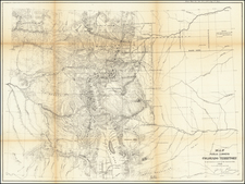
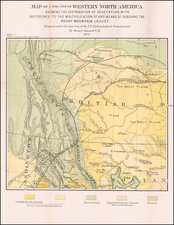
An Exceptional Rarity -- The Earliest Atlas Map To Focus On The American Northwest
Focusing on the region traversed by Lewis & Clark, this rare German map is one of rarest cartographic works of the 1820s. Issued separately as part of a serial set of maps intended to be bound up as an atlas, The map is one of the best post-Lewis & Clark maps to capture the essence of the American West prior to Annexation of California, etc.
Rare separate map of Oregon Territory and Missouri, published in Weimar in 1828.
This extremely rare map of the two Territories is one of the earliest printed mas to focus on the region, drawing from Arrowsmith, Lewis & Clark, the Hudson Bay Company and others for the regional details. The text even references Finley's 1826 Atlas.
The text section provides a detailed accounting of the two Territories, among the earliest such descriptions printed in German.
Weiland's Atlas of America.
The map is part of a series of maps published by C.F. Weiland over a course of a number of years, which were intended to be bound up as an Atlas of America.
The maps for Carl Ferdinand Weiland's "American Atlas" were published between 1823 and 1829 in Weimar by the Geographisches Instituts. C.F. Weiland was one of the most prolific mapmakers in early 19th Century Germany. In his treatise on 19th Century maps published in Germany, Jurgen Espenhorst devotes the better part of 75 pages describing the many and varied productions of the Weiland and the Weimar Geographisches Institut.
C.F. Weiland's first cartographic work was published in the early 19th Century. During the next half century, dozens of different works appear bearing his name and maps. One of the most enigmatic of these publications is his so-called "Atlas von Amerika." Espenhorst opines that sometime after the publication of Carey & Lea's Geographical Statistical & Historical Atlas of America in Philadelphia in 1822, Weiland commenced publication of his own atlas of America, employing the same style as Carey & Lea, who had in turn copied the historical atlas format first used by Las Casas.
Espenhorst states:
Of special interest is the Atlas von America [Atlas of the Americas] published by C.F. Weiland and Georg Hassel from 1823 to 1829. . .
For a long time it remained unclear just what precursors Weiland was referring to. All that was known was that the work was based on an atlas that had been created by Henry Charles Lea Carey (1793-1879) and Isaac Lea (1792-1886) and published in 1822 at their house in Philadelphia. . .
. . . Carey and Lea first applied the Las Casas concept to a geographical atlas. the result was a cartographic work with 46 maps, covering all parts of North, Central and South America.
This work produced great interest in Europe almost immediately. The countries of the Spanish Empire in Central and South America had just achieved their independence as a result of popular uprisings, and people were eager to learn about these new nations. As a result, the Carey/Lea atlas was republished in London in 1823, with identical content, but a new title page. Two years later, Jean Alexandre C. Burton [sic] published a French version of the Americas atlas in Paris, which contained 51 maps.
In Weimar, work toward the publication of a German version of the Carey/Lea work must have begun immediately after a copy of the atlas arrived from Philadelphia in 1822. Three sheets were already being offered in the Neue Allgemeine Ephemeriden in 1823. On these sheets, the content of the accompanying text focused on the map around which the text was arranged.
The principal author appears to have been Georg Hassel, because the publication o the atlas ended when he died in 1829.
The publishing house had great hopes for this project, and worked hard to keep the maps up to date. Delivery of installments began in 1823; by the beginning of 1824 seven sheets, covering Central and South America, had been published. By 1826 a number of the maps had been revised, some of them as many as three times.
Of the 52 sheets which were originally planned, 51 were maps. It would appear that not all of them were finally published, however. It is not clear why the remaining five sheets did not appear. The most complete version the author has been able to verify contains only 46 maps. Altogether eight copies are known to the author [Four copies in the US-Library of Congress and University of Chicago (30 maps), National Geographic Society (31 maps) and Roger Baskes (35 maps). Three copies in Germany, Peutinger Gymnasium Ellswanger and Peterman copies (39 maps) Staatsbibliothek zu Berlin 46 maps) Peterman was also aware of a 4th example which was sold in Germany in the 1970s).
Thus, the map sheets of the German version of the Atlas of the Americas must be regarded as extremely rare. On the other hand, the identification of this work is very difficult inasmuch as the sheets have neither page numbers, author names, nor titles. The only identifying information is the inscription "Weimar, im Verlag des Geographischen Instituts. 182x." . . . It is therefore entirely possible that there are other maps from this work which have not been correctly catalogued.
Espenhorst, p.156-160.
At page 156, Espenhorst illustrates a table, which he states is "the only known table of contents for the Atlas Von Amerika ." In footnote 192, Espenhorst notes the source as NAGE 17 (1825) and states that "this article, which was designed to promote the sale of the atlas, contained an exact list of all the planned sheets of the Atlas." As noted above, of the 52 plates listed in the 1825 printed list of maps, Espenhorst was able to locate examples of 46 maps. According to Espenhorst (footnote 193), five maps (America, North America, United States, Bahamas & Cuba and Puerto Rico) and the statistical table were apparently never printed.
In May 2010, a previously unrecorded private example was offered for sale at auction. This private example, purchased by Barry Lawrence Ruderman Antique Maps and Antiquariat Reinhold Berg, included 60 maps, including a number of duplicates (including 2 different states of at least 3 of the maps) and a previously unrecorded map of Mittelamerica which was not listed in either of the 1825 lists. Of the remaining extra maps, 5 were from other Weiland publications (America, North America, United States, South America and the European Ottoman Empire) and 2 were maps in the same Las Casas format for other regions (Aegypten and Birma).
The example also included a advertising and contents list in broadsheet format with the following title:
Ueberischt
des
geographisch-statistisch-historichen
Atlas von Amerika,
welcher die Charten aller Staaten v on Nord- und Sud-
Amerika, so wie Westindiens mid beigedrucktem, von Hrn.
Professor Dr. Hassel gearbeitenten, geographisch-statisti-
schen und historischen Texte liefert
Following the title was a list of 50 maps, followed by a description of the project. The following is a translation of the title and additional text:
Summary of the geographical statistical, and historical atlas of America,
which includes maps of all states of North and South America, as
well as the West Indies, with geographical, statistical and
historical text, prepared by Professor Dr. Hassel, surrounding each map.
------------------
We have added the following 2 maps to this atlas, which describes all states of the
western hemisphere on 50 maps (in Imperial Folio):
51) The North Polar Regions, with Greenland and Spitzbergen
52) Patagonia, the Firelands and the South Polar Regions,
which, of course, strictly speaking, do not belong with the maps of the states of America;
however, to complete our geographical description of America, these areas must be included.
Twenty-three of the maps (those marked with an * in the table of contents) listed above have already been distributed by our publishing house. The other maps will follow one after another. It should also be noted that some of the South American regional maps have been updated since they were first published, due to changes which required that the maps be newly engraved and re-worked.The maps which have been updated and revised are marked with ** in the table of contents.
Price of one map on ordinary paper. 8 Saxonian-Groschen or 36 Rhine-
Kreuzer, on Velin paper 12 Saxonian-Groschen or 54 Rhine-Kreuzer.
Weimar, October 1825.
The Geographical Institute.
The 23 maps which are noted as having been engraved to date were, New Hampshire, Massachusetts, Connecticut, New York, New Jersey, Pennsylvania, Delaware, South Carolina, Georgia, Ohio, Tennessee, Louisiana, Alabama, Mexico, Guatemala, Cuba & Bahamas, Jamaica, Haiti, Columbia, Brazil, Peru, Chile, and La Plata.
The map which had been updated were Mexico, Columbia and Brazil.
The maps which are referenced above are all dated 1825 and earlier.
In the present group, in addition to the duplicated maps of Mexico (1824 and 1828) and Brazil, there are duplicate maps of Louisiana, Haiti, Guatemala (with a new province Veracruz named in the south), Chile and Peru.
We were not able to locate any changes in the maps of Louisiana, Haiti or Peru. The Chile map plate is re-set within the larger plate, but we found no other differences.