|
||

|

|
|

|
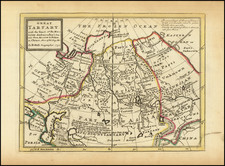
The Wang Jun Fu World Map: A Prized Rarity of East Asian Cartography.
Superb hand-colored woodblock (or xylographic) map of the world, representing a milestone in Sino-Japanese cartography of the world. The map features China as the center of the world, with the other countries of the world rendered as peripheral and subservient.
The naval expeditions sponsored by the Yongle emperor and led by Zheng He between 1405 and 1433 to explore Southeast Asia, Arabia, and East Africa vastly expanded the horizons of Chinese geographers. Mapmakers gradually adjusted their views to accommodate spheres beyond the customary tributary states, but their renditions of the Chinese empire continued to emphasize its central role in the cosmos. After Matteo Ricci and his successors (such as Ferdinand Verbiest) in the late Ming and early Qing eras introduced world maps with a vastly expanded universe—and a correspondingly contracted China—some Chinese cartographers responded with their own versions of the world system. The complete map of human events and travel routes of the nine frontiers and myriad countries under heaven 天下九邊萬國人跡路程全圖, derived from a 1644 map by Cao Junyi 曹君義, provided one of these hybrid visions—the dominating land mass of China surrounded by countries that seem to decline in size as they leave China’s cultural orbit. Within China it uses elaborate symbolism to differentiate among provinces, prefectures, subprefectures, counties, districts and various categories of cities. On a reduced scale, Europe and Africa (clustered around the Mediterranean) huddle in the upper northwest corner, while North and South America occupy their respective nooks in the extreme northeast and southeast corners of the map. Some countries (including Korea and Japan) are represented by cartouches with text, while the farther frontiers of the map are inhabited by legendary races and creatures of the imagination. -- Harvard-Yenching Library
The Map and its Publication History
The map has introductory text at the top, flanking the title, which gives details on the countries of the world and gives a brief list of sources for the map. The legend on the left fives details for 33 foreign countries including mythical nations discussed in the ancient text Shanhai Jing. On the right, the legend lists 29 important border crossings.
The Wang Jun Fu map was based on a Ming dynasty representation of the world, the Tianxia jiubian fenye renji luceng quan tu , which was privately printed by Cao Junyi in Nanjing in 1644. In turn, that map was copied in Suzhou by Wang Jun Fu in Kangxi 2 (1663). The present map retains the original Chinese text and date but was published by a Japanese printer in Kyoto between 1680 and 1710.
The map also derives some of its information from Jesuit sources, including the Ricci map.
![[ The Lost Paulus Ageminius Casket Map ]](https://storage.googleapis.com/raremaps/img/small/97534.jpg)