|
||

|

|
|

|
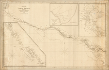
Brobidngnag and the Island of California -- From Gulliver's Travels
Fine example of the mythical map of the region from Monterey, California to Brobingnag, Flanflasnic and Lorbrulgrud, as prepared to illustrate Part II of Gullivers Travels.
The map illustrates a mythical region north of the Island of California and the Straits of Anian, discovered by Gulliver in 1703. Other place names mentioned include Cape Blanco, St. Sebastian, Cape Mendocino and the Port of Sir Francis Drake, a reference to Drake's Landfall in California, at Drake's Bay, north of San Francisco, in 1579.
The map appeared in the first edition of Gulliver's Travels. The full title is:
Travels Into Several Remote Nations of the World; By Lemuel Gulliver, First a Surgeon, and then a Captain of seveal Ships. In Four Parts. Part I. A Voyage to Lilliput. Part II. A Voyage to Brobdingnag. Part II. A Voyage to Laputa, Balnibarbi, Luggnagg, Glubbdubrib, and Japan. Part IV. A Voyage to the Country of the Houyhnhnms. London, Printed for C. Bathurst. MDCCLXVIII
Gulliver's Travels is a prose satire by Irish writer and clergyman Jonathan Swift, that is both a satire on human nature and the "travellers' tales" literary subgenre. It is Swift's best known full-length work, and a classic of English literature. He himself claimed that he wrote Gulliver's Travels "to vex the world rather than divert it". The book became popular as soon as it was published. John Gay wrote in a 1726 letter to Swift that "It is universally read, from the cabinet council to the nursery."
Gulliver begins his travels in May of 1699 and travels until December 1715.
The present map appeared in the 1768 edition of the book.
![[ Pacific Northwest - Northwest Passage ] Limes Occidentis Quivira et Anian. 1597](https://storage.googleapis.com/raremaps/img/small/71207.jpg)