|
||

|

|
|

|
Early certified copy of the detailed map of an early addition to the town of Wells, Nevada, surveyed by F.H. Russell, Civil Engineer.
The map shows the newly planned subdivision on either side of the Central Pacific Railroad Depot and Warehouse. A public school site is also shown.
The site of Wells began as a place called Humboldt Wells along the trail to California. It was subsequently founded as a railroad town along the original Transcontinental Railroad, and was once a stopover for passenger trains.
In September, 1869, Humboldt Wells was established as a station on the Union Pacific Railroad: a Wells Fargo office, a log shanty saloon, and the station office in a boxcar.
By 1872, stores and hotels had been added to the single business street paralleling the west side of the tracks, and stagecoaches ran south into White Pine County three times a week. Devastating fires in 1877, 1881 and 1900 interrupted development, and lacking any business beyond that provided by the railroad and the ranches, growth was very slow.
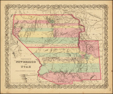
![Parts of E. California and S. E. Nevada, N.W. Arizona and S.W. Utah __ Atlas Sheet No. 66 [Shows Las Vegas!]](https://storage.googleapis.com/raremaps/img/small/92030.jpg)