|
||

|

|
|

|
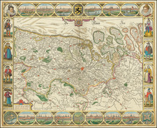
Nice example of this scarce map of Belgium.
This map is based on a map by Ortelius dated 1570. The map appeared in Geographisch Handbuch in welchem die gelegenheit der vornembsten Landschafften des geantzen Erdbodems in zweij und achtzig in Kupffer geschnittenen Tafeln furgebilt (?.)…
This map is the first edition of the map, with Albrecht (left portrait) shown as a Cardinal. In the second, he is shown as a nobleman. The portrait changed when he married Isabella and was compelled to give up his religious title.
The present map was produced by two of the primary Cologne School mapmakers, Johann Bussemacher and Matthias Quad. The Cologne School of cartography, was perhaps the only group of mapmakers competing with the Low Countries-based map publishing houses at the end of the 16th century (De Jode and Ortelius). For more on the Cologne School, see: Meurer, Atlantes Colonienses. Die Kolner Schule der Atlas Kartographie 1570-1610.
Matthias Quad (1557-1613), a map publisher based in Cologne, was trained in the Netherlands by Johannes van Doetecum, who also worked with the De Jodes. Quad used many De Jode maps as a base to which he added additional information and decorations. Quad was best known for his atlases, which were part of the first boom in atlases best characterized by Abraham Ortelius’ Theatrum Orbis Terrarum. In 1592, Quad released an atlas of Europe that had 38 maps. He expanded it in 1594 to 50 maps. In 1600, he expanded the collection of maps further still, this time to 82 maps, and called the atlas, Geographisch Handtbuch. All three were small in size, allowing them to compete as cheaper alternatives to the larger atlases of Ortelius, Mercator, and the De Jodes. Quad released one other atlas, in 1608, with 86 maps, the Fascilus Geographicus.
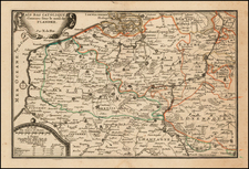
![[ Belgium & Luxembourg ] Belgii Pars Meridionalis cum Occientalibus Germaniae et Septentrionalis Franciae Confiniis peraccurate in hanc Tabulam redacta](https://storage.googleapis.com/raremaps/img/small/98438.jpg)
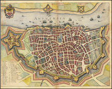
![[Antwerp]](https://storage.googleapis.com/raremaps/img/small/91034.jpg)