
This item has been sold, but you can enter your email address to be notified if another example becomes available.


|
||

|

|
|

|
Stock# 54761
Description
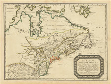
Rare English Map of the St. Lawrence River, extending from Lake Ontario and Thousand Islands to just north of Quebec.
The chart shows hannels, islands, shoals, waterfalls, rocks and rapids in the river. Also shows towns, forts and place names in the river valley. This depiction was originally an inset in D'Anville's 4-sheet map.
Reference
Kershaw #681; Sellers & Van Ee #251.
![[MacKenzie River, Yukon Territory and Northwest Territory] Amer. Sep. No. 15. Grand Lac De L'Esclave](https://storage.googleapis.com/raremaps/img/small/19469.jpg)
![[ Discovery of the Northwest Passage ] Chart Showing the Recent Search for a North-West Passage. Also the Coast Explored in Search of Sir John Franklin between the Years 1848 and 1854](https://storage.googleapis.com/raremaps/img/small/101874.jpg)