|
||

|

|
|

|
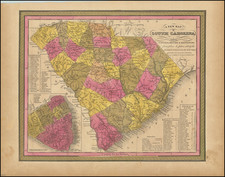
Nice example of the Mark Catesby's rare map of the Southeastern part of North America, extending from the Eastern Seaboard to the Mississippi River and north to include the southern part of Virginia.
Catesby's map was published in the first natural history of American flora and fauna. The map illustrates the area from just beyond the Mississippi River to Cape Charles in the north, and in the south from the Yucatan Peninsula through Cuba and the Bahamas to Puerto Rico. It is among the earliest maps on which Georgia appears. The map is based in part on John Barnwell's manuscript map of circa 1722 and presents a great deal of information on the location of French, Spanish, Indian and English settlements and details not found on earlier printed maps. It also derives from Henry Popple's great map of 1733. As with the natural history drawings that appeared in Catesby's work, the striking title cartouche is composed of shells and coral.
This is also one of the earliest maps to name the Colony of Georgia.
Catesby's map was based largely on Henry Popple's A Map of the British Empire in America with the French and Spanish Settlements adjacent thereto." The subscribers to Mark Catesby's celebrated Natural History received this map bound into their volumes to illustrate the area with which Catesby dealt in his famous work illustrating plants, animals, birds, fish, and insects of America. This scarce map is considered by many to be one of the most highly prized maps of the colonial South.
Catesby's Natural History of Carolina, Florida and the Bahama Islands was the first natural history of American flora and fauna. First issued between 1731 and 1743, this work would eventually include 220 prints, which for the first time systematically illustrated American birds, animals and plants. Following his studies in South Carolina and a year in the Bahamas, Catesby returned to England. There he spent the next two decades writing, engraving and publishing his Natural History of the Carolinas, Florida, and the Bahama Islands. It was not only the first fully-illustrated natural history of North America, but also a major contribution to both art and science.
To view a short video on this map by map collector Thomas Touchton, click here: https://www.youtube.com/watch?v=qxvCQ5yX4gc
There are two states of the map:
- On the first state (1733-54), French Louisiana, on both sides of the Mississippi, was colored green.
- On the second state (1771 to circa 1815), the territory east of the Mississippi is colored green showing the part of Louisiana that had been acquired by Britain; the territory to the west, which now belonged to Spain, is colored blue. This example is from the edition published in the early part of the nineteenth century with the watermark - J Whatman 1815. The English versions of this map, in any edition, rarely appear on the market
Rarity
Catesby's map is quite rare on the market. This is the third example of the map we have offered in the past 25 years.